You are here: Home > Network List > XE05 - Sierra Nevada EarthScope Project- EarthScope Flex Array Stations List
> Station SNP74 SNP74 > Earthquake Result Viewer
SNP74 SNP74 - Earthquake Result Viewer
| Earthquake location: |
New Ireland Region, P.N.G. |
| Earthquake latitude/longitude: |
-4.5/153.5 |
| Earthquake time(UTC): |
2005/09/09 (252) 07:26:43 GMT |
| Earthquake Depth: |
90 km |
| Earthquake Magnitude: |
6.3 MB, 7.7 MW, 7.5 MW |
| Earthquake Catalog/Contributor: |
WHDF/NEIC |
|
| Network: |
XE Sierra Nevada EarthScope Project- EarthScope Flex Array |
| Station: |
SNP74 SNP74 |
| Lat/Lon: |
37.99 N/119.93 W |
| Elevation: |
1684 m |
|
| Distance: |
90.1 deg |
| Az: |
52.071 deg |
| Baz: |
264.352 deg |
| Ray Param: |
0.0416818 |
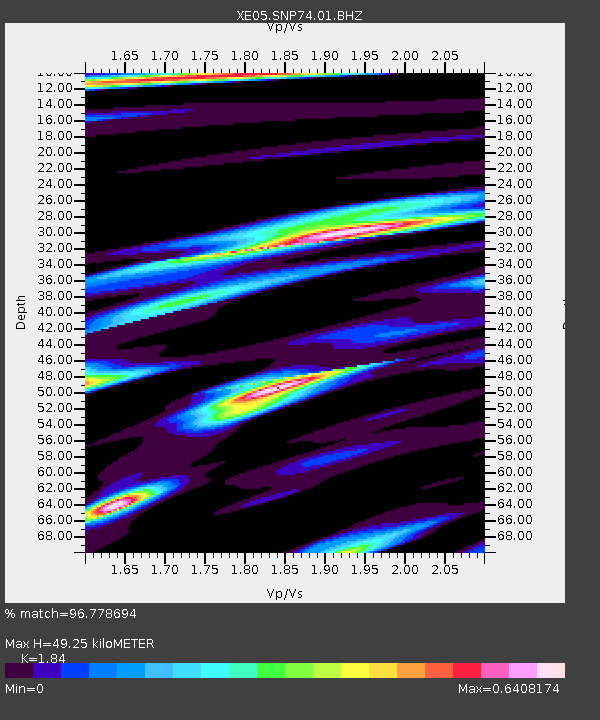
| Estimated Moho Depth: |
49.25 km |
| Estimated Crust Vp/Vs: |
1.84 |
| Assumed Crust Vp: |
6.291 km/s |
| Estimated Crust Vs: |
3.419 km/s |
| Estimated Crust Poisson's Ratio: |
0.29 |
|
| Radial Match: |
96.778694 % |
| Radial Bump: |
363 |
| Transverse Match: |
87.31253 % |
| Transverse Bump: |
400 |
| SOD ConfigId: |
268666 |
| Insert Time: |
2010-03-09 16:56:15.544 +0000 |
| GWidth: |
2.5 |
| Max Bumps: |
400 |
| Tol: |
0.001 |
|

Signal To Noise
| Channel | StoN | STA | LTA |
| XE:SNP74:01:BHZ:20050909T07:39:02.334004Z | 11.130832 | 1.0296673E-6 | 9.250587E-8 |
| XE:SNP74:01:BHN:20050909T07:39:02.334004Z | 1.1036115 | 5.878543E-8 | 5.326642E-8 |
| XE:SNP74:01:BHE:20050909T07:39:02.334004Z | 7.478543 | 3.6962288E-7 | 4.9424454E-8 |
| Arrivals |
| Ps | 6.7 SECOND |
| PpPs | 22 SECOND |
| PsPs/PpSs | 29 SECOND |


