You are here: Home > Network List > XE05 - Sierra Nevada EarthScope Project- EarthScope Flex Array Stations List
> Station SNP74 SNP74 > Earthquake Result Viewer
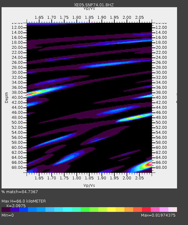
SNP74 SNP74 - Earthquake Result Viewer
| Earthquake location: |
Fiji Islands Region |
| Earthquake latitude/longitude: |
-21.2/-176.3 |
| Earthquake time(UTC): |
2006/08/15 (227) 23:53:47 GMT |
| Earthquake Depth: |
158 km |
| Earthquake Magnitude: |
5.9 MB, 6.1 MW, 6.1 MW |
| Earthquake Catalog/Contributor: |
WHDF/NEIC |
|
| Network: |
XE Sierra Nevada EarthScope Project- EarthScope Flex Array |
| Station: |
SNP74 SNP74 |
| Lat/Lon: |
37.99 N/119.93 W |
| Elevation: |
1684 m |
|
| Distance: |
79.1 deg |
| Az: |
42.034 deg |
| Baz: |
232.259 deg |
| Ray Param: |
0.0487902 |
| Estimated Moho Depth: |
66.0 km |
| Estimated Crust Vp/Vs: |
2.10 |
| Assumed Crust Vp: |
6.291 km/s |
| Estimated Crust Vs: |
2.999 km/s |
| Estimated Crust Poisson's Ratio: |
0.35 |
|
| Radial Match: |
84.7367 % |
| Radial Bump: |
400 |
| Transverse Match: |
80.266304 % |
| Transverse Bump: |
400 |
| SOD ConfigId: |
268666 |
| Insert Time: |
2010-03-09 16:56:43.274 +0000 |
| GWidth: |
2.5 |
| Max Bumps: |
400 |
| Tol: |
0.001 |
|

Signal To Noise
| Channel | StoN | STA | LTA |
| XE:SNP74:01:BHZ:20060816T00:05:03.213999Z | 17.390804 | 8.69734E-7 | 5.0011142E-8 |
| XE:SNP74:01:BHN:20060816T00:05:03.213999Z | 3.63128 | 2.2997011E-7 | 6.333032E-8 |
| XE:SNP74:01:BHE:20060816T00:05:03.213999Z | 4.790508 | 3.5206784E-7 | 7.34928E-8 |
| Arrivals |
| Ps | 12 SECOND |
| PpPs | 32 SECOND |
| PsPs/PpSs | 44 SECOND |


