You are here: Home > Network List > XE05 - Sierra Nevada EarthScope Project- EarthScope Flex Array Stations List
> Station SNP74 SNP74 > Earthquake Result Viewer
SNP74 SNP74 - Earthquake Result Viewer
| Earthquake location: |
Near East Coast Of Kamchatka |
| Earthquake latitude/longitude: |
55.6/161.7 |
| Earthquake time(UTC): |
2006/08/17 (229) 11:11:35 GMT |
| Earthquake Depth: |
55 km |
| Earthquake Magnitude: |
6.1 MB, 5.7 MW, 5.7 MW |
| Earthquake Catalog/Contributor: |
WHDF/NEIC |
|
| Network: |
XE Sierra Nevada EarthScope Project- EarthScope Flex Array |
| Station: |
SNP74 SNP74 |
| Lat/Lon: |
37.99 N/119.93 W |
| Elevation: |
1684 m |
|
| Distance: |
53.5 deg |
| Az: |
74.362 deg |
| Baz: |
316.261 deg |
| Ray Param: |
0.06592151 |
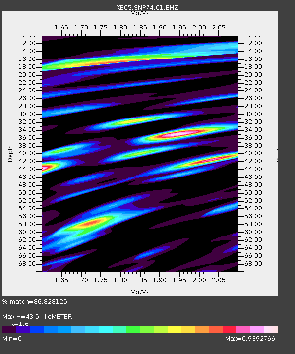
| Estimated Moho Depth: |
43.5 km |
| Estimated Crust Vp/Vs: |
1.60 |
| Assumed Crust Vp: |
6.291 km/s |
| Estimated Crust Vs: |
3.932 km/s |
| Estimated Crust Poisson's Ratio: |
0.18 |
|
| Radial Match: |
86.828125 % |
| Radial Bump: |
400 |
| Transverse Match: |
81.21192 % |
| Transverse Bump: |
400 |
| SOD ConfigId: |
268666 |
| Insert Time: |
2010-03-09 16:56:47.863 +0000 |
| GWidth: |
2.5 |
| Max Bumps: |
400 |
| Tol: |
0.001 |
|

Signal To Noise
| Channel | StoN | STA | LTA |
| XE:SNP74:01:BHZ:20060817T11:20:19.690024Z | 23.625124 | 1.3905919E-6 | 5.8860724E-8 |
| XE:SNP74:01:BHN:20060817T11:20:19.690024Z | 6.562169 | 4.9345925E-7 | 7.5197576E-8 |
| XE:SNP74:01:BHE:20060817T11:20:19.690024Z | 13.312387 | 5.940351E-7 | 4.462273E-8 |
| Arrivals |
| Ps | 4.4 SECOND |
| PpPs | 17 SECOND |
| PsPs/PpSs | 21 SECOND |


