You are here: Home > Network List > XE05 - Sierra Nevada EarthScope Project- EarthScope Flex Array Stations List
> Station SNP74 SNP74 > Earthquake Result Viewer
SNP74 SNP74 - Earthquake Result Viewer
| Earthquake location: |
Santiago Del Estero Prov., Arg. |
| Earthquake latitude/longitude: |
-26.0/-63.2 |
| Earthquake time(UTC): |
2006/11/13 (317) 01:26:34 GMT |
| Earthquake Depth: |
552 km |
| Earthquake Magnitude: |
6.3 MB, 6.8 MW, 6.8 MW |
| Earthquake Catalog/Contributor: |
WHDF/NEIC |
|
| Network: |
XE Sierra Nevada EarthScope Project- EarthScope Flex Array |
| Station: |
SNP74 SNP74 |
| Lat/Lon: |
37.99 N/119.93 W |
| Elevation: |
1684 m |
|
| Distance: |
83.0 deg |
| Az: |
318.277 deg |
| Baz: |
130.736 deg |
| Ray Param: |
0.044903565 |
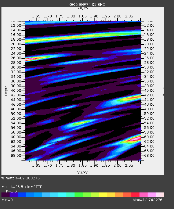
| Estimated Moho Depth: |
26.5 km |
| Estimated Crust Vp/Vs: |
1.60 |
| Assumed Crust Vp: |
6.291 km/s |
| Estimated Crust Vs: |
3.932 km/s |
| Estimated Crust Poisson's Ratio: |
0.18 |
|
| Radial Match: |
89.303276 % |
| Radial Bump: |
400 |
| Transverse Match: |
77.137436 % |
| Transverse Bump: |
400 |
| SOD ConfigId: |
268666 |
| Insert Time: |
2010-03-09 16:57:08.669 +0000 |
| GWidth: |
2.5 |
| Max Bumps: |
400 |
| Tol: |
0.001 |
|

Signal To Noise
| Channel | StoN | STA | LTA |
| XE:SNP74:01:BHZ:20061113T01:37:30.340015Z | 1.407742 | 3.764727E-7 | 2.674302E-7 |
| XE:SNP74:01:BHN:20061113T01:37:30.340015Z | 1.8590362 | 2.8013326E-7 | 1.5068737E-7 |
| XE:SNP74:01:BHE:20061113T01:37:30.340015Z | 0.7503189 | 3.5270958E-7 | 4.7007958E-7 |
| Arrivals |
| Ps | 2.6 SECOND |
| PpPs | 11 SECOND |
| PsPs/PpSs | 13 SECOND |


