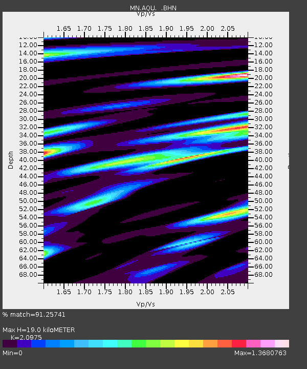
AQU L'Aquila, Italy - Earthquake Result Viewer
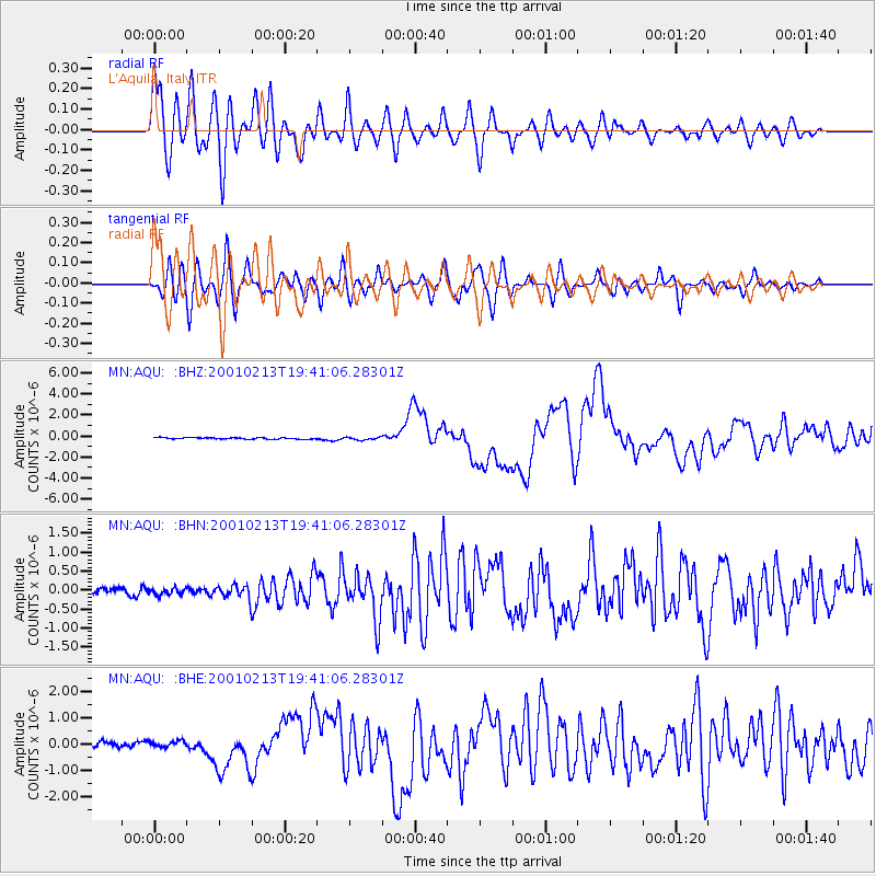
Earthquake location: Southern Sumatra, Indonesia
Earthquake latitude/longitude: -4.7/102.6
Earthquake time(UTC): 2001/02/13 (044) 19:28:30 GMT
Earthquake Depth: 36 km
Earthquake Magnitude: 6.2 MB, 7.2 MS, 7.4 MW, 7.0 ME
Earthquake Catalog/Contributor: WHDF/NEIC
Network: MN MEDNET Project
Station: AQU L'Aquila, Italy
Lat/Lon: 42.35 N/13.40 E
Elevation: 710 m
Distance: 92.5 deg
Az: 312.109 deg
Baz: 94.013 deg
Ray Param: 0.041434616
Estimated Moho Depth: 19.0 km
Estimated Crust Vp/Vs: 2.10
Assumed Crust Vp: 6.276 km/s
Estimated Crust Vs: 2.992 km/s
Estimated Crust Poisson's Ratio: 0.35
Radial Match: 91.25741 %
Radial Bump: 400
Transverse Match: 87.21087 %
Transverse Bump: 400
SOD ConfigId: 3744
Insert Time: 2010-02-26 16:22:55.050 +0000
GWidth: 2.5
Max Bumps: 400
Tol: 0.001

Signal To Noise

ChannelStoNSTALTA
MN:AQU: :BHN:20010213T19:41:06.28301Z1.02527698.79462E-88.577799E-8
MN:AQU: :BHE:20010213T19:41:06.28301Z1.26770481.18747124E-79.3670955E-8
MN:AQU: :BHZ:20010213T19:41:06.28301Z1.72482511.2424772E-77.2034965E-8
Arrivals
Ps3.4 SECOND
PpPs9.2 SECOND
PsPs/PpSs13 SECOND