You are here: Home > Network List > IU - Global Seismograph Network (GSN - IRIS/USGS) Stations List
> Station CTAO Charters Towers, Australia > Earthquake Result Viewer
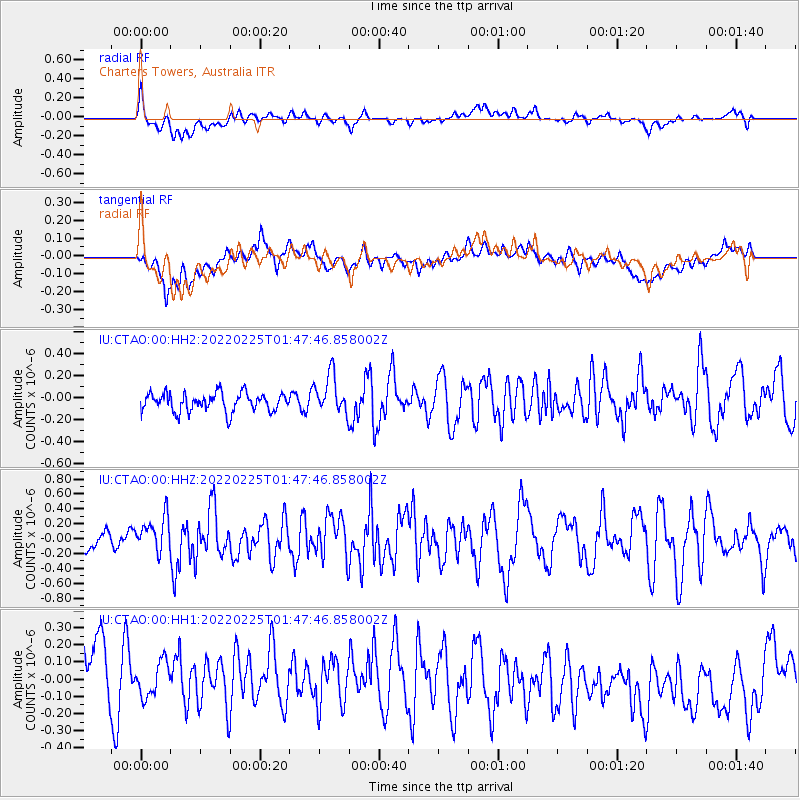
CTAO Charters Towers, Australia - Earthquake Result Viewer
*The percent match for this event was below the threshold and hence no stack was calculated.
| Earthquake location: |
Northern Sumatra, Indonesia |
| Earthquake latitude/longitude: |
0.2/100.1 |
| Earthquake time(UTC): |
2022/02/25 (056) 01:39:27 GMT |
| Earthquake Depth: |
12 km |
| Earthquake Magnitude: |
6.2 mww |
| Earthquake Catalog/Contributor: |
NEIC PDE/us |
|
| Network: |
IU Global Seismograph Network (GSN - IRIS/USGS) |
| Station: |
CTAO Charters Towers, Australia |
| Lat/Lon: |
20.09 S/146.25 E |
| Elevation: |
367 m |
|
| Distance: |
49.5 deg |
| Az: |
116.914 deg |
| Baz: |
288.434 deg |
| Ray Param: |
$rayparam |
*The percent match for this event was below the threshold and hence was not used in the summary stack. |
|
| Radial Match: |
46.858566 % |
| Radial Bump: |
400 |
| Transverse Match: |
43.457283 % |
| Transverse Bump: |
400 |
| SOD ConfigId: |
26694651 |
| Insert Time: |
2022-03-11 01:44:51.988 +0000 |
| GWidth: |
2.5 |
| Max Bumps: |
400 |
| Tol: |
0.001 |
|
Signal To Noise
| Channel | StoN | STA | LTA |
| IU:CTAO:00:HHZ:20220225T01:47:46.858002Z | 1.8868032 | 2.2920636E-7 | 1.2147868E-7 |
| IU:CTAO:00:HH1:20220225T01:47:46.858002Z | 0.6700791 | 9.9914395E-8 | 1.4910836E-7 |
| IU:CTAO:00:HH2:20220225T01:47:46.858002Z | 2.126112 | 1.7646099E-7 | 8.299703E-8 |
| Arrivals |
| Ps | |
| PpPs | |
| PsPs/PpSs | |


