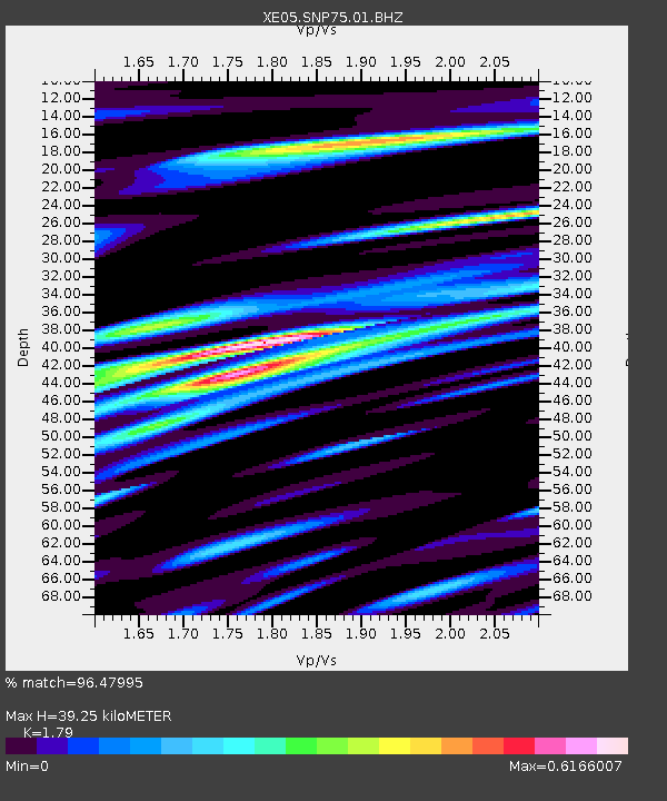
SNP75 SNP75 - Earthquake Result Viewer

Earthquake location: Kuril Islands
Earthquake latitude/longitude: 46.4/153.2
Earthquake time(UTC): 2006/09/30 (273) 17:50:23 GMT
Earthquake Depth: 11 km
Earthquake Magnitude: 6.1 MB, 6.5 MS, 6.6 MW, 6.6 MW
Earthquake Catalog/Contributor: WHDF/NEIC
Network: XE Sierra Nevada EarthScope Project- EarthScope Flex Array
Station: SNP75 SNP75
Lat/Lon: 38.13 N/119.70 W
Elevation: 2665 m
Distance: 61.9 deg
Az: 63.223 deg
Baz: 308.361 deg
Ray Param: 0.06056759
Estimated Moho Depth: 39.25 km
Estimated Crust Vp/Vs: 1.79
Assumed Crust Vp: 6.279 km/s
Estimated Crust Vs: 3.508 km/s
Estimated Crust Poisson's Ratio: 0.27
Radial Match: 96.47995 %
Radial Bump: 400
Transverse Match: 87.239136 %
Transverse Bump: 400
SOD ConfigId: 268666
Insert Time: 2010-03-09 17:00:28.389 +0000
GWidth: 2.5
Max Bumps: 400
Tol: 0.001

Signal To Noise

ChannelStoNSTALTA
XE:SNP75:01:BHZ:20060930T18:00:11.440015Z4.9120475.6670507E-71.15370455E-7
XE:SNP75:01:BHN:20060930T18:00:11.440015Z3.36732632.789514E-78.284062E-8
XE:SNP75:01:BHE:20060930T18:00:11.440015Z2.79000621.9483694E-76.9833874E-8
Arrivals
Ps5.2 SECOND
PpPs17 SECOND
PsPs/PpSs22 SECOND