You are here: Home > Network List > G - GEOSCOPE Stations List
> Station RER Riviere de l'Est, La Reunion (Indian Ocean) > Earthquake Result Viewer
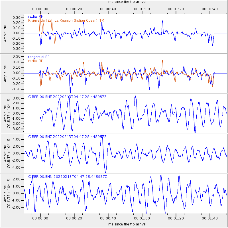
RER Riviere de l'Est, La Reunion (Indian Ocean) - Earthquake Result Viewer
*The percent match for this event was below the threshold and hence no stack was calculated.
| Earthquake location: |
Philippine Islands Region |
| Earthquake latitude/longitude: |
19.1/121.2 |
| Earthquake time(UTC): |
2022/02/13 (044) 04:36:17 GMT |
| Earthquake Depth: |
28 km |
| Earthquake Magnitude: |
5.5 mww |
| Earthquake Catalog/Contributor: |
NEIC PDE/us |
|
| Network: |
G GEOSCOPE |
| Station: |
RER Riviere de l'Est, La Reunion (Indian Ocean) |
| Lat/Lon: |
21.16 S/55.75 E |
| Elevation: |
834 m |
|
| Distance: |
75.5 deg |
| Az: |
241.249 deg |
| Baz: |
62.629 deg |
| Ray Param: |
$rayparam |
*The percent match for this event was below the threshold and hence was not used in the summary stack. |
|
| Radial Match: |
42.524174 % |
| Radial Bump: |
400 |
| Transverse Match: |
60.56808 % |
| Transverse Bump: |
400 |
| SOD ConfigId: |
26694651 |
| Insert Time: |
2022-03-12 03:24:59.903 +0000 |
| GWidth: |
2.5 |
| Max Bumps: |
400 |
| Tol: |
0.001 |
|
Signal To Noise
| Channel | StoN | STA | LTA |
| G:RER:00:BHZ:20220213T04:47:28.448987Z | 2.459629 | 2.117466E-6 | 8.608883E-7 |
| G:RER:00:BHN:20220213T04:47:28.448987Z | 0.85883164 | 8.5997294E-7 | 1.0013289E-6 |
| G:RER:00:BHE:20220213T04:47:28.448987Z | 0.5981636 | 9.595964E-7 | 1.6042372E-6 |
| Arrivals |
| Ps | |
| PpPs | |
| PsPs/PpSs | |


