You are here: Home > Network List > MN - MEDNET Project Stations List
> Station AQU L'Aquila, Italy > Earthquake Result Viewer
AQU L'Aquila, Italy - Earthquake Result Viewer
| Earthquake location: |
Sunda Strait, Indonesia |
| Earthquake latitude/longitude: |
-7.0/104.2 |
| Earthquake time(UTC): |
2002/06/27 (178) 05:50:35 GMT |
| Earthquake Depth: |
11 km |
| Earthquake Magnitude: |
6.0 MB, 6.9 MS, 6.6 MW, 6.5 MW |
| Earthquake Catalog/Contributor: |
WHDF/NEIC |
|
| Network: |
MN MEDNET Project |
| Station: |
AQU L'Aquila, Italy |
| Lat/Lon: |
42.35 N/13.40 E |
| Elevation: |
710 m |
|
| Distance: |
95.2 deg |
| Az: |
311.905 deg |
| Baz: |
94.622 deg |
| Ray Param: |
0.040842373 |
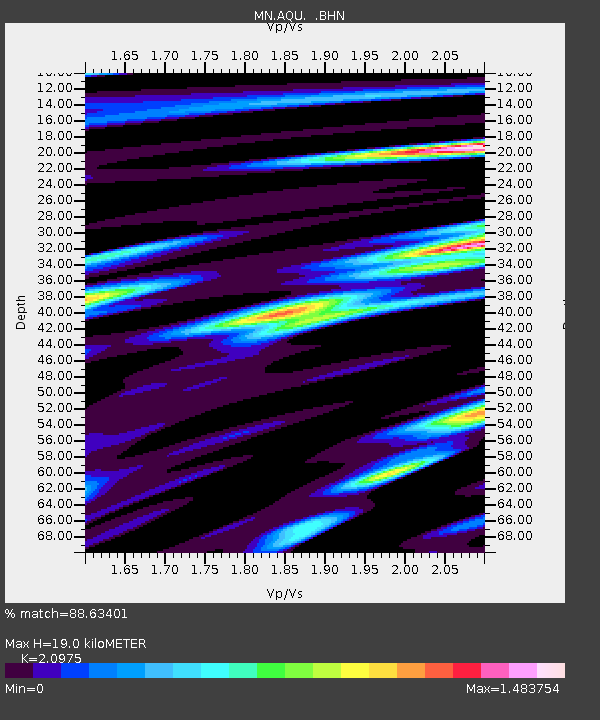
| Estimated Moho Depth: |
19.0 km |
| Estimated Crust Vp/Vs: |
2.10 |
| Assumed Crust Vp: |
6.276 km/s |
| Estimated Crust Vs: |
2.992 km/s |
| Estimated Crust Poisson's Ratio: |
0.35 |
|
| Radial Match: |
88.63401 % |
| Radial Bump: |
400 |
| Transverse Match: |
79.40244 % |
| Transverse Bump: |
400 |
| SOD ConfigId: |
20082 |
| Insert Time: |
2010-02-26 16:23:14.760 +0000 |
| GWidth: |
2.5 |
| Max Bumps: |
400 |
| Tol: |
0.001 |
|

Signal To Noise
| Channel | StoN | STA | LTA |
| MN:AQU: :BHN:20020627T06:03:26.88002Z | 0.75749314 | 1.5435009E-7 | 2.0376433E-7 |
| MN:AQU: :BHE:20020627T06:03:26.88002Z | 1.166753 | 2.281425E-7 | 1.9553623E-7 |
| MN:AQU: :BHZ:20020627T06:03:26.88002Z | 5.621906 | 5.2397087E-7 | 9.320164E-8 |
| Arrivals |
| Ps | 3.4 SECOND |
| PpPs | 9.2 SECOND |
| PsPs/PpSs | 13 SECOND |


