You are here: Home > Network List > AV - Alaska Volcano Observatory Stations List
> Station SPCR Ckakachatna River, Mount Spurr, Alaska > Earthquake Result Viewer
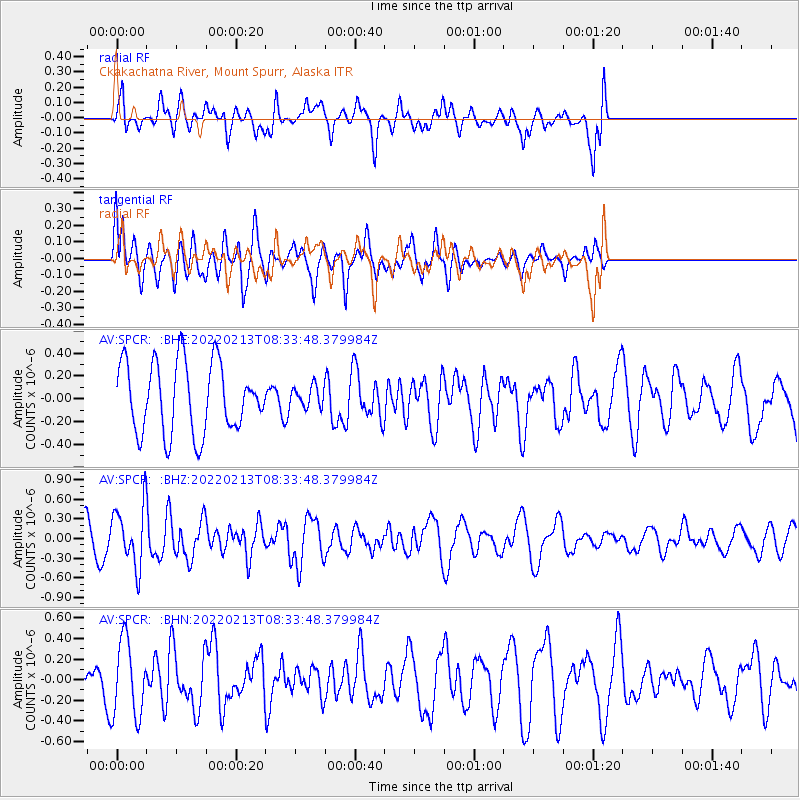
SPCR Ckakachatna River, Mount Spurr, Alaska - Earthquake Result Viewer
*The percent match for this event was below the threshold and hence no stack was calculated.
| Earthquake location: |
Northern Molucca Sea |
| Earthquake latitude/longitude: |
0.9/126.3 |
| Earthquake time(UTC): |
2022/02/13 (044) 08:21:46 GMT |
| Earthquake Depth: |
31 km |
| Earthquake Magnitude: |
5.7 mww |
| Earthquake Catalog/Contributor: |
NEIC PDE/us |
|
| Network: |
AV Alaska Volcano Observatory |
| Station: |
SPCR Ckakachatna River, Mount Spurr, Alaska |
| Lat/Lon: |
61.20 N/152.21 W |
| Elevation: |
984 m |
|
| Distance: |
85.1 deg |
| Az: |
28.732 deg |
| Baz: |
263.026 deg |
| Ray Param: |
$rayparam |
*The percent match for this event was below the threshold and hence was not used in the summary stack. |
|
| Radial Match: |
59.64484 % |
| Radial Bump: |
400 |
| Transverse Match: |
45.583286 % |
| Transverse Bump: |
400 |
| SOD ConfigId: |
26694651 |
| Insert Time: |
2022-03-12 07:30:22.867 +0000 |
| GWidth: |
2.5 |
| Max Bumps: |
400 |
| Tol: |
0.001 |
|
Signal To Noise
| Channel | StoN | STA | LTA |
| AV:SPCR: :BHZ:20220213T08:33:48.379984Z | 1.7033995 | 4.5622716E-7 | 2.6783331E-7 |
| AV:SPCR: :BHN:20220213T08:33:48.379984Z | 1.7261152 | 3.6771266E-7 | 2.1302903E-7 |
| AV:SPCR: :BHE:20220213T08:33:48.379984Z | 0.30084175 | 9.2588216E-8 | 3.0776386E-7 |
| Arrivals |
| Ps | |
| PpPs | |
| PsPs/PpSs | |


