You are here: Home > Network List > UW - Pacific Northwest Regional Seismic Network Stations List
> Station HOOD Mt Hood Meadows, OR CREST BB SMO > Earthquake Result Viewer
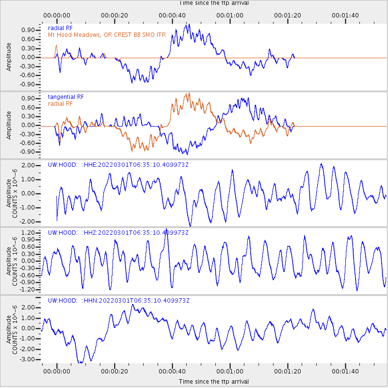
HOOD Mt Hood Meadows, OR CREST BB SMO - Earthquake Result Viewer
*The percent match for this event was below the threshold and hence no stack was calculated.
| Earthquake location: |
Kermadec Islands Region |
| Earthquake latitude/longitude: |
-27.2/-175.9 |
| Earthquake time(UTC): |
2022/03/01 (060) 06:22:54 GMT |
| Earthquake Depth: |
10 km |
| Earthquake Magnitude: |
5.8 mww |
| Earthquake Catalog/Contributor: |
NEIC PDE/us |
|
| Network: |
UW Pacific Northwest Regional Seismic Network |
| Station: |
HOOD Mt Hood Meadows, OR CREST BB SMO |
| Lat/Lon: |
45.32 N/121.65 W |
| Elevation: |
1520 m |
|
| Distance: |
87.4 deg |
| Az: |
34.965 deg |
| Baz: |
226.355 deg |
| Ray Param: |
$rayparam |
*The percent match for this event was below the threshold and hence was not used in the summary stack. |
|
| Radial Match: |
68.69016 % |
| Radial Bump: |
400 |
| Transverse Match: |
59.516785 % |
| Transverse Bump: |
400 |
| SOD ConfigId: |
26694651 |
| Insert Time: |
2022-03-15 06:43:32.058 +0000 |
| GWidth: |
2.5 |
| Max Bumps: |
400 |
| Tol: |
0.001 |
|
Signal To Noise
| Channel | StoN | STA | LTA |
| UW:HOOD: :HHZ:20220301T06:35:10.409973Z | 0.75773865 | 3.9086834E-7 | 5.1583527E-7 |
| UW:HOOD: :HHN:20220301T06:35:10.409973Z | 1.2274545 | 1.0401034E-6 | 8.4736615E-7 |
| UW:HOOD: :HHE:20220301T06:35:10.409973Z | 1.0419964 | 7.6073576E-7 | 7.3007527E-7 |
| Arrivals |
| Ps | |
| PpPs | |
| PsPs/PpSs | |


