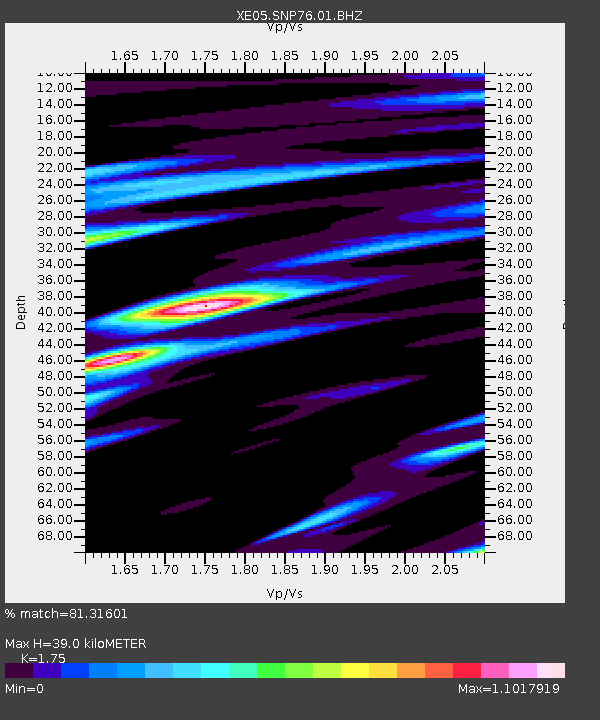
SNP76 SNP76 - Earthquake Result Viewer

Earthquake location: Mariana Islands Region
Earthquake latitude/longitude: 20.8/146.2
Earthquake time(UTC): 2006/02/14 (045) 15:27:23 GMT
Earthquake Depth: 40 km
Earthquake Magnitude: 6.2 MB, 6.1 MS, 6.3 MW, 6.2 MW
Earthquake Catalog/Contributor: WHDF/NEIC
Network: XE Sierra Nevada EarthScope Project- EarthScope Flex Array
Station: SNP76 SNP76
Lat/Lon: 38.36 N/119.51 W
Elevation: 2106 m
Distance: 80.6 deg
Az: 52.614 deg
Baz: 289.0 deg
Ray Param: 0.048099577
Estimated Moho Depth: 39.0 km
Estimated Crust Vp/Vs: 1.75
Assumed Crust Vp: 6.279 km/s
Estimated Crust Vs: 3.588 km/s
Estimated Crust Poisson's Ratio: 0.26
Radial Match: 81.31601 %
Radial Bump: 400
Transverse Match: 60.018898 %
Transverse Bump: 400
SOD ConfigId: 268666
Insert Time: 2010-03-09 17:03:42.122 +0000
GWidth: 2.5
Max Bumps: 400
Tol: 0.001

Signal To Noise

ChannelStoNSTALTA
XE:SNP76:01:BHZ:20060214T15:39:00.709019Z5.48233751.7486099E-63.1895334E-7
XE:SNP76:01:BHN:20060214T15:39:00.709019Z1.24548524.6784527E-73.7563294E-7
XE:SNP76:01:BHE:20060214T15:39:00.709019Z2.50033955.877777E-72.3507917E-7
Arrivals
Ps4.8 SECOND
PpPs17 SECOND
PsPs/PpSs21 SECOND