You are here: Home > Network List > AK - Alaska Regional Network Stations List
> Station BAT Barry Arm Top, AK, USA > Earthquake Result Viewer
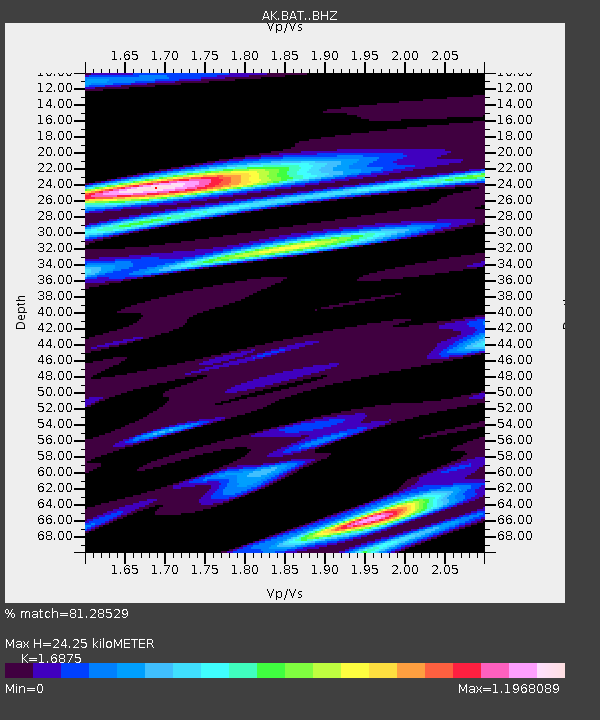
BAT Barry Arm Top, AK, USA - Earthquake Result Viewer
| Earthquake location: |
Kermadec Islands, New Zealand |
| Earthquake latitude/longitude: |
-30.1/-177.7 |
| Earthquake time(UTC): |
2022/03/02 (061) 12:52:07 GMT |
| Earthquake Depth: |
24 km |
| Earthquake Magnitude: |
6.6 mww |
| Earthquake Catalog/Contributor: |
NEIC PDE/us |
|
| Network: |
AK Alaska Regional Network |
| Station: |
BAT Barry Arm Top, AK, USA |
| Lat/Lon: |
61.14 N/148.18 W |
| Elevation: |
1027 m |
|
| Distance: |
94.0 deg |
| Az: |
13.879 deg |
| Baz: |
205.378 deg |
| Ray Param: |
0.041132394 |
| Estimated Moho Depth: |
24.25 km |
| Estimated Crust Vp/Vs: |
1.69 |
| Assumed Crust Vp: |
6.566 km/s |
| Estimated Crust Vs: |
3.891 km/s |
| Estimated Crust Poisson's Ratio: |
0.23 |
|
| Radial Match: |
81.28529 % |
| Radial Bump: |
400 |
| Transverse Match: |
76.51341 % |
| Transverse Bump: |
400 |
| SOD ConfigId: |
26694651 |
| Insert Time: |
2022-03-16 12:57:06.934 +0000 |
| GWidth: |
2.5 |
| Max Bumps: |
400 |
| Tol: |
0.001 |
|

Signal To Noise
| Channel | StoN | STA | LTA |
| AK:BAT: :BHZ:20220302T13:04:51.79997Z | 7.2309947 | 8.20503E-7 | 1.1347027E-7 |
| AK:BAT: :BHN:20220302T13:04:51.79997Z | 3.9646187 | 2.9953E-7 | 7.555077E-8 |
| AK:BAT: :BHE:20220302T13:04:51.79997Z | 4.315059 | 3.2422486E-7 | 7.513798E-8 |
| Arrivals |
| Ps | 2.6 SECOND |
| PpPs | 9.7 SECOND |
| PsPs/PpSs | 12 SECOND |


