You are here: Home > Network List > IU - Global Seismograph Network (GSN - IRIS/USGS) Stations List
> Station PMSA Palmer Station, Antarctica > Earthquake Result Viewer
PMSA Palmer Station, Antarctica - Earthquake Result Viewer

| Earthquake location: |
Kermadec Islands, New Zealand |
| Earthquake latitude/longitude: |
-30.1/-177.7 |
| Earthquake time(UTC): |
2022/03/02 (061) 12:52:07 GMT |
| Earthquake Depth: |
24 km |
| Earthquake Magnitude: |
6.6 mww |
| Earthquake Catalog/Contributor: |
NEIC PDE/us |
|
| Network: |
IU Global Seismograph Network (GSN - IRIS/USGS) |
| Station: |
PMSA Palmer Station, Antarctica |
| Lat/Lon: |
64.77 S/64.05 W |
| Elevation: |
40 m |
|
| Distance: |
72.5 deg |
| Az: |
155.696 deg |
| Baz: |
236.361 deg |
| Ray Param: |
0.053625114 |
| Estimated Moho Depth: |
28.25 km |
| Estimated Crust Vp/Vs: |
1.71 |
| Assumed Crust Vp: |
6.183 km/s |
| Estimated Crust Vs: |
3.616 km/s |
| Estimated Crust Poisson's Ratio: |
0.24 |
|
| Radial Match: |
85.70539 % |
| Radial Bump: |
400 |
| Transverse Match: |
63.030003 % |
| Transverse Bump: |
400 |
| SOD ConfigId: |
26694651 |
| Insert Time: |
2022-03-16 13:09:01.109 +0000 |
| GWidth: |
2.5 |
| Max Bumps: |
400 |
| Tol: |
0.001 |
|
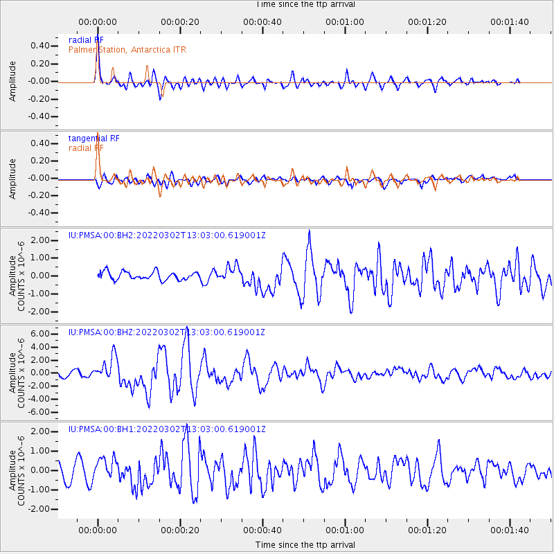
Signal To Noise
| Channel | StoN | STA | LTA |
| IU:PMSA:00:BHZ:20220302T13:03:00.619001Z | 3.9498277 | 1.9377471E-6 | 4.905903E-7 |
| IU:PMSA:00:BH1:20220302T13:03:00.619001Z | 1.3354508 | 5.8222673E-7 | 4.3597768E-7 |
| IU:PMSA:00:BH2:20220302T13:03:00.619001Z | 1.9200268 | 4.240598E-7 | 2.208614E-7 |
| Arrivals |
| Ps | 3.4 SECOND |
| PpPs | 12 SECOND |
| PsPs/PpSs | 15 SECOND |


