You are here: Home > Network List > IU - Global Seismograph Network (GSN - IRIS/USGS) Stations List
> Station SLBS Sierra la Laguna Baja California Sur, Mexico > Earthquake Result Viewer
SLBS Sierra la Laguna Baja California Sur, Mexico - Earthquake Result Viewer
| Earthquake location: |
Kermadec Islands, New Zealand |
| Earthquake latitude/longitude: |
-30.1/-177.7 |
| Earthquake time(UTC): |
2022/03/02 (061) 12:52:07 GMT |
| Earthquake Depth: |
24 km |
| Earthquake Magnitude: |
6.6 mww |
| Earthquake Catalog/Contributor: |
NEIC PDE/us |
|
| Network: |
IU Global Seismograph Network (GSN - IRIS/USGS) |
| Station: |
SLBS Sierra la Laguna Baja California Sur, Mexico |
| Lat/Lon: |
23.69 N/109.94 W |
| Elevation: |
825 m |
|
| Distance: |
84.2 deg |
| Az: |
58.548 deg |
| Baz: |
233.766 deg |
| Ray Param: |
0.045635626 |
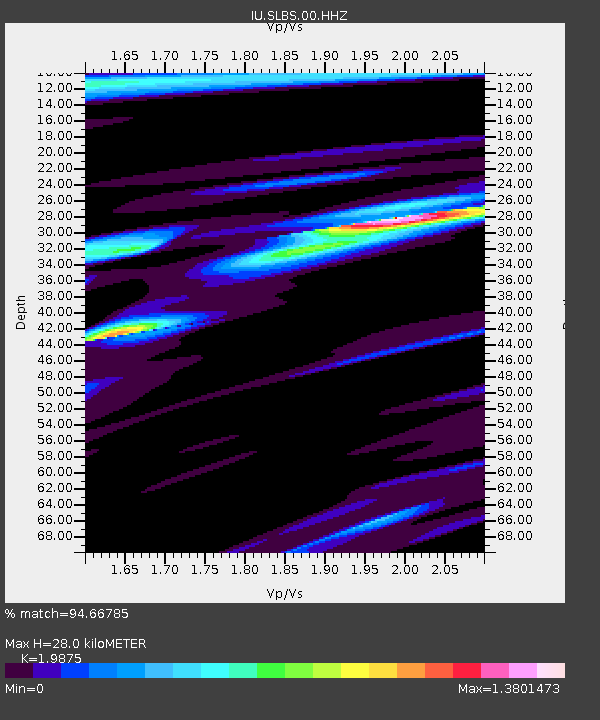
| Estimated Moho Depth: |
28.0 km |
| Estimated Crust Vp/Vs: |
1.99 |
| Assumed Crust Vp: |
6.183 km/s |
| Estimated Crust Vs: |
3.111 km/s |
| Estimated Crust Poisson's Ratio: |
0.33 |
|
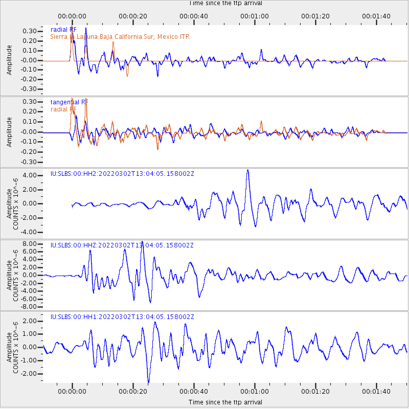
| Radial Match: |
94.66785 % |
| Radial Bump: |
338 |
| Transverse Match: |
82.21835 % |
| Transverse Bump: |
399 |
| SOD ConfigId: |
26694651 |
| Insert Time: |
2022-03-16 13:09:05.664 +0000 |
| GWidth: |
2.5 |
| Max Bumps: |
400 |
| Tol: |
0.001 |
|
Signal To Noise
| Channel | StoN | STA | LTA |
| IU:SLBS:00:HHZ:20220302T13:04:05.158002Z | 2.7955396 | 8.921168E-7 | 3.1912148E-7 |
| IU:SLBS:00:HH1:20220302T13:04:05.158002Z | 1.5156127 | 2.8092768E-7 | 1.8535584E-7 |
| IU:SLBS:00:HH2:20220302T13:04:05.158002Z | 1.3462732 | 2.3070636E-7 | 1.7136668E-7 |
| Arrivals |
| Ps | 4.6 SECOND |
| PpPs | 13 SECOND |
| PsPs/PpSs | 18 SECOND |


