You are here: Home > Network List > US - United States National Seismic Network Stations List
> Station HAWA Hanford, Washington, USA > Earthquake Result Viewer
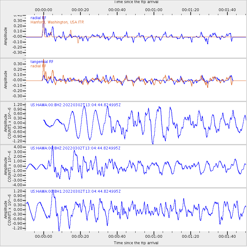
HAWA Hanford, Washington, USA - Earthquake Result Viewer
*The percent match for this event was below the threshold and hence no stack was calculated.
| Earthquake location: |
Kermadec Islands, New Zealand |
| Earthquake latitude/longitude: |
-30.1/-177.7 |
| Earthquake time(UTC): |
2022/03/02 (061) 12:52:07 GMT |
| Earthquake Depth: |
24 km |
| Earthquake Magnitude: |
6.6 mww |
| Earthquake Catalog/Contributor: |
NEIC PDE/us |
|
| Network: |
US United States National Seismic Network |
| Station: |
HAWA Hanford, Washington, USA |
| Lat/Lon: |
46.39 N/119.53 W |
| Elevation: |
364 m |
|
| Distance: |
92.5 deg |
| Az: |
36.07 deg |
| Baz: |
227.508 deg |
| Ray Param: |
$rayparam |
*The percent match for this event was below the threshold and hence was not used in the summary stack. |
|
| Radial Match: |
58.393517 % |
| Radial Bump: |
386 |
| Transverse Match: |
66.20169 % |
| Transverse Bump: |
400 |
| SOD ConfigId: |
26694651 |
| Insert Time: |
2022-03-16 13:15:42.585 +0000 |
| GWidth: |
2.5 |
| Max Bumps: |
400 |
| Tol: |
0.001 |
|
Signal To Noise
| Channel | StoN | STA | LTA |
| US:HAWA:00:BHZ:20220302T13:04:44.824995Z | 2.7927384 | 1.269324E-6 | 4.5450875E-7 |
| US:HAWA:00:BH1:20220302T13:04:44.824995Z | 1.2967106 | 4.2557244E-7 | 3.2819383E-7 |
| US:HAWA:00:BH2:20220302T13:04:44.824995Z | 1.1158345 | 5.4345975E-7 | 4.8704334E-7 |
| Arrivals |
| Ps | |
| PpPs | |
| PsPs/PpSs | |


