You are here: Home > Network List > US - United States National Seismic Network Stations List
> Station MSO Missoula, Montana, USA > Earthquake Result Viewer
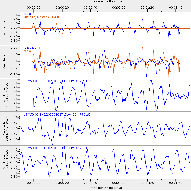
MSO Missoula, Montana, USA - Earthquake Result Viewer
*The percent match for this event was below the threshold and hence no stack was calculated.
| Earthquake location: |
Kermadec Islands, New Zealand |
| Earthquake latitude/longitude: |
-30.1/-177.7 |
| Earthquake time(UTC): |
2022/03/02 (061) 12:52:07 GMT |
| Earthquake Depth: |
24 km |
| Earthquake Magnitude: |
6.6 mww |
| Earthquake Catalog/Contributor: |
NEIC PDE/us |
|
| Network: |
US United States National Seismic Network |
| Station: |
MSO Missoula, Montana, USA |
| Lat/Lon: |
46.83 N/113.94 W |
| Elevation: |
1264 m |
|
| Distance: |
95.7 deg |
| Az: |
38.249 deg |
| Baz: |
231.404 deg |
| Ray Param: |
$rayparam |
*The percent match for this event was below the threshold and hence was not used in the summary stack. |
|
| Radial Match: |
61.015232 % |
| Radial Bump: |
400 |
| Transverse Match: |
34.274075 % |
| Transverse Bump: |
336 |
| SOD ConfigId: |
26694651 |
| Insert Time: |
2022-03-16 13:15:49.541 +0000 |
| GWidth: |
2.5 |
| Max Bumps: |
400 |
| Tol: |
0.001 |
|
Signal To Noise
| Channel | StoN | STA | LTA |
| US:MSO:00:BHZ:20220302T13:04:59.475019Z | 3.3435357 | 6.6217933E-7 | 1.9804763E-7 |
| US:MSO:00:BH1:20220302T13:04:59.475019Z | 0.4265712 | 1.3112943E-7 | 3.0740338E-7 |
| US:MSO:00:BH2:20220302T13:04:59.475019Z | 0.85737526 | 3.3381448E-7 | 3.8934465E-7 |
| Arrivals |
| Ps | |
| PpPs | |
| PsPs/PpSs | |


