You are here: Home > Network List > US - United States National Seismic Network Stations List
> Station DGMT Dagmar, Montana, USA > Earthquake Result Viewer
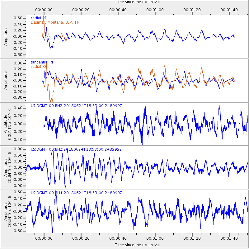
DGMT Dagmar, Montana, USA - Earthquake Result Viewer
*The percent match for this event was below the threshold and hence no stack was calculated.
| Earthquake location: |
Central East Pacific Rise |
| Earthquake latitude/longitude: |
-9.0/-108.5 |
| Earthquake time(UTC): |
2018/06/24 (175) 18:43:42 GMT |
| Earthquake Depth: |
10 km |
| Earthquake Magnitude: |
5.7 Mww |
| Earthquake Catalog/Contributor: |
NEIC PDE/us |
|
| Network: |
US United States National Seismic Network |
| Station: |
DGMT Dagmar, Montana, USA |
| Lat/Lon: |
48.47 N/104.20 W |
| Elevation: |
0.0 m |
|
| Distance: |
57.4 deg |
| Az: |
3.432 deg |
| Baz: |
185.097 deg |
| Ray Param: |
$rayparam |
*The percent match for this event was below the threshold and hence was not used in the summary stack. |
|
| Radial Match: |
61.288208 % |
| Radial Bump: |
400 |
| Transverse Match: |
53.74113 % |
| Transverse Bump: |
400 |
| SOD ConfigId: |
2738091 |
| Insert Time: |
2018-07-08 18:51:26.908 +0000 |
| GWidth: |
2.5 |
| Max Bumps: |
400 |
| Tol: |
0.001 |
|
Signal To Noise
| Channel | StoN | STA | LTA |
| US:DGMT:00:BHZ:20180624T18:53:00.248999Z | 5.8473744 | 4.840101E-7 | 8.277393E-8 |
| US:DGMT:00:BH1:20180624T18:53:00.248999Z | 1.0432992 | 2.0137259E-7 | 1.930152E-7 |
| US:DGMT:00:BH2:20180624T18:53:00.248999Z | 1.1162003 | 1.3756355E-7 | 1.232427E-7 |
| Arrivals |
| Ps | |
| PpPs | |
| PsPs/PpSs | |


