You are here: Home > Network List > MN - MEDNET Project Stations List
> Station AQU L'Aquila, Italy > Earthquake Result Viewer
AQU L'Aquila, Italy - Earthquake Result Viewer

| Earthquake location: |
Hokkaido, Japan Region |
| Earthquake latitude/longitude: |
43.0/145.1 |
| Earthquake time(UTC): |
2004/11/28 (333) 18:32:14 GMT |
| Earthquake Depth: |
39 km |
| Earthquake Magnitude: |
6.4 MB, 6.7 MS, 7.0 MW, 7.0 MW |
| Earthquake Catalog/Contributor: |
WHDF/NEIC |
|
| Network: |
MN MEDNET Project |
| Station: |
AQU L'Aquila, Italy |
| Lat/Lon: |
42.35 N/13.40 E |
| Elevation: |
710 m |
|
| Distance: |
84.6 deg |
| Az: |
326.234 deg |
| Baz: |
33.37 deg |
| Ray Param: |
0.045319337 |
| Estimated Moho Depth: |
52.25 km |
| Estimated Crust Vp/Vs: |
1.60 |
| Assumed Crust Vp: |
6.276 km/s |
| Estimated Crust Vs: |
3.916 km/s |
| Estimated Crust Poisson's Ratio: |
0.18 |
|
| Radial Match: |
91.81539 % |
| Radial Bump: |
400 |
| Transverse Match: |
87.66752 % |
| Transverse Bump: |
400 |
| SOD ConfigId: |
2459 |
| Insert Time: |
2010-02-26 16:23:54.357 +0000 |
| GWidth: |
2.5 |
| Max Bumps: |
400 |
| Tol: |
0.001 |
|
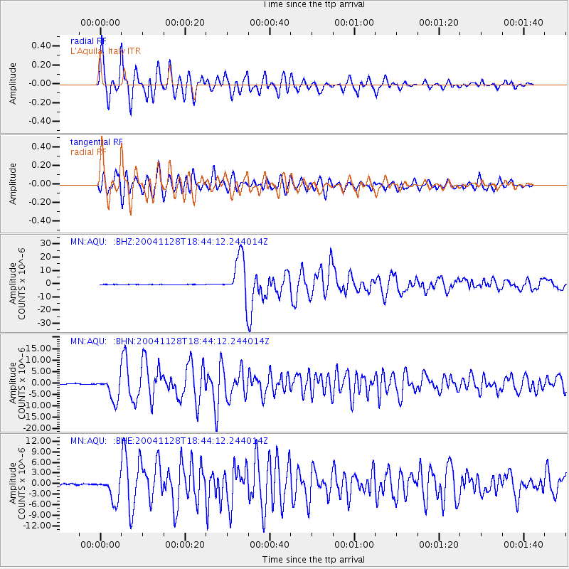
Signal To Noise
| Channel | StoN | STA | LTA |
| MN:AQU: :BHN:20041128T18:44:12.244014Z | 32.220768 | 5.363806E-6 | 1.6647044E-7 |
| MN:AQU: :BHE:20041128T18:44:12.244014Z | 18.629627 | 3.460849E-6 | 1.8577124E-7 |
| MN:AQU: :BHZ:20041128T18:44:12.244014Z | 163.72253 | 1.6844733E-5 | 1.02885856E-7 |
| Arrivals |
| Ps | 5.1 SECOND |
| PpPs | 21 SECOND |
| PsPs/PpSs | 26 SECOND |


