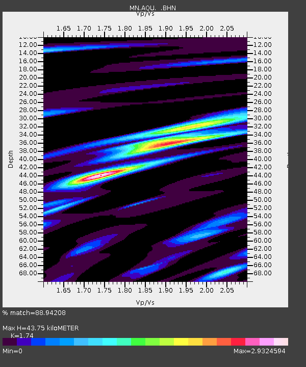
AQU L'Aquila, Italy - Earthquake Result Viewer

Earthquake location: Queen Charlotte Islands Region
Earthquake latitude/longitude: 54.8/-134.2
Earthquake time(UTC): 2004/06/28 (180) 09:49:47 GMT
Earthquake Depth: 20 km
Earthquake Magnitude: 5.9 MB, 6.8 MS, 6.8 MW, 6.8 MW
Earthquake Catalog/Contributor: WHDF/NEIC
Network: MN MEDNET Project
Station: AQU L'Aquila, Italy
Lat/Lon: 42.35 N/13.40 E
Elevation: 710 m
Distance: 79.4 deg
Az: 23.798 deg
Baz: 341.627 deg
Ray Param: 0.04899711
Estimated Moho Depth: 43.75 km
Estimated Crust Vp/Vs: 1.74
Assumed Crust Vp: 6.276 km/s
Estimated Crust Vs: 3.607 km/s
Estimated Crust Poisson's Ratio: 0.25
Radial Match: 88.94208 %
Radial Bump: 400
Transverse Match: 77.81706 %
Transverse Bump: 400
SOD ConfigId: 2459
Insert Time: 2010-02-26 16:24:17.207 +0000
GWidth: 2.5
Max Bumps: 400
Tol: 0.001

Signal To Noise

ChannelStoNSTALTA
MN:AQU: :BHN:20040628T10:01:20.02301Z2.00891782.6464522E-71.3173522E-7
MN:AQU: :BHE:20040628T10:01:20.02301Z1.16295851.6189728E-71.3921156E-7
MN:AQU: :BHZ:20040628T10:01:20.02301Z7.3605235.6803077E-77.717261E-8
Arrivals
Ps5.3 SECOND
PpPs19 SECOND
PsPs/PpSs24 SECOND