AQU L'Aquila, Italy - Earthquake Result Viewer
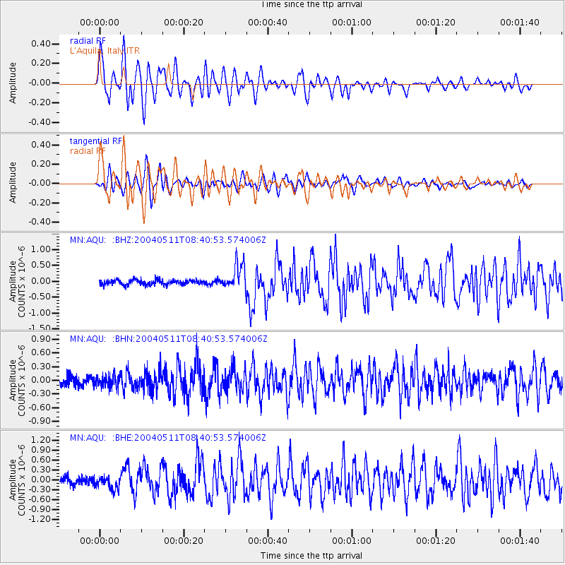
Earthquake location: Northern Sumatra, Indonesia
Earthquake latitude/longitude: 0.4/97.8
Earthquake time(UTC): 2004/05/11 (132) 08:28:48 GMT
Earthquake Depth: 21 km
Earthquake Magnitude: 5.6 MB, 6.2 MS, 6.1 MW, 6.1 MW
Earthquake Catalog/Contributor: WHDF/NEIC
Network: MN MEDNET Project
Station: AQU L'Aquila, Italy
Lat/Lon: 42.35 N/13.40 E
Elevation: 710 m
Distance: 85.6 deg
Az: 312.275 deg
Baz: 93.446 deg
Ray Param: 0.044636365
Estimated Moho Depth: 40.5 km
Estimated Crust Vp/Vs: 1.91
Assumed Crust Vp: 6.276 km/s
Estimated Crust Vs: 3.286 km/s
Estimated Crust Poisson's Ratio: 0.31
Radial Match: 92.9593 %
Radial Bump: 400
Transverse Match: 84.660355 %
Transverse Bump: 400
SOD ConfigId: 2459
Insert Time: 2010-02-26 16:24:30.135 +0000
GWidth: 2.5
Max Bumps: 400
Tol: 0.001

Signal To Noise

ChannelStoNSTALTA
MN:AQU: :BHN:20040511T08:40:53.574006Z1.14711441.2913691E-71.12575435E-7
MN:AQU: :BHE:20040511T08:40:53.574006Z1.74580321.9573237E-71.12115934E-7
MN:AQU: :BHZ:20040511T08:40:53.574006Z5.37135744.090506E-77.6154045E-8
Arrivals
Ps6.0 SECOND
PpPs18 SECOND
PsPs/PpSs24 SECOND