You are here: Home > Network List > XE05 - Sierra Nevada EarthScope Project- EarthScope Flex Array Stations List
> Station SNP86 SNP86 > Earthquake Result Viewer
SNP86 SNP86 - Earthquake Result Viewer
| Earthquake location: |
New Ireland Region, P.N.G. |
| Earthquake latitude/longitude: |
-4.5/153.5 |
| Earthquake time(UTC): |
2005/09/09 (252) 07:26:43 GMT |
| Earthquake Depth: |
90 km |
| Earthquake Magnitude: |
6.3 MB, 7.7 MW, 7.5 MW |
| Earthquake Catalog/Contributor: |
WHDF/NEIC |
|
| Network: |
XE Sierra Nevada EarthScope Project- EarthScope Flex Array |
| Station: |
SNP86 SNP86 |
| Lat/Lon: |
38.49 N/119.81 W |
| Elevation: |
2632 m |
|
| Distance: |
90.2 deg |
| Az: |
51.576 deg |
| Baz: |
264.43 deg |
| Ray Param: |
0.041671295 |
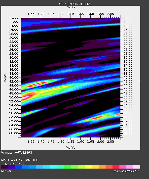
| Estimated Moho Depth: |
50.25 km |
| Estimated Crust Vp/Vs: |
1.60 |
| Assumed Crust Vp: |
6.279 km/s |
| Estimated Crust Vs: |
3.918 km/s |
| Estimated Crust Poisson's Ratio: |
0.18 |
|
| Radial Match: |
97.42493 % |
| Radial Bump: |
319 |
| Transverse Match: |
86.88456 % |
| Transverse Bump: |
400 |
| SOD ConfigId: |
268666 |
| Insert Time: |
2010-03-09 17:18:54.044 +0000 |
| GWidth: |
2.5 |
| Max Bumps: |
400 |
| Tol: |
0.001 |
|

Signal To Noise
| Channel | StoN | STA | LTA |
| XE:SNP86:01:BHZ:20050909T07:39:03.005024Z | 13.020156 | 1.1862186E-6 | 9.110632E-8 |
| XE:SNP86:01:BHN:20050909T07:39:03.005024Z | 1.7987908 | 1.2017668E-7 | 6.6809704E-8 |
| XE:SNP86:01:BHE:20050909T07:39:03.005024Z | 6.748559 | 4.2231585E-7 | 6.257867E-8 |
| Arrivals |
| Ps | 4.9 SECOND |
| PpPs | 20 SECOND |
| PsPs/PpSs | 25 SECOND |


