You are here: Home > Network List > XE05 - Sierra Nevada EarthScope Project- EarthScope Flex Array Stations List
> Station SNP87 SNP87 > Earthquake Result Viewer
SNP87 SNP87 - Earthquake Result Viewer
| Earthquake location: |
Sea Of Japan |
| Earthquake latitude/longitude: |
36.8/134.9 |
| Earthquake time(UTC): |
2007/07/16 (197) 14:17:37 GMT |
| Earthquake Depth: |
350 km |
| Earthquake Magnitude: |
6.2 MB, 6.8 MW, 6.8 MW |
| Earthquake Catalog/Contributor: |
WHDF/NEIC |
|
| Network: |
XE Sierra Nevada EarthScope Project- EarthScope Flex Array |
| Station: |
SNP87 SNP87 |
| Lat/Lon: |
38.68 N/119.61 W |
| Elevation: |
2708 m |
|
| Distance: |
78.3 deg |
| Az: |
50.364 deg |
| Baz: |
307.844 deg |
| Ray Param: |
0.048776787 |
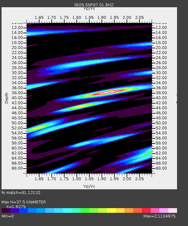
| Estimated Moho Depth: |
37.5 km |
| Estimated Crust Vp/Vs: |
1.93 |
| Assumed Crust Vp: |
6.279 km/s |
| Estimated Crust Vs: |
3.257 km/s |
| Estimated Crust Poisson's Ratio: |
0.32 |
|
| Radial Match: |
81.12132 % |
| Radial Bump: |
400 |
| Transverse Match: |
85.390114 % |
| Transverse Bump: |
400 |
| SOD ConfigId: |
268666 |
| Insert Time: |
2010-03-09 17:22:02.646 +0000 |
| GWidth: |
2.5 |
| Max Bumps: |
400 |
| Tol: |
0.001 |
|

Signal To Noise
| Channel | StoN | STA | LTA |
| XE:SNP87:01:BHZ:20070716T14:28:28.209019Z | 67.572205 | 3.7438822E-6 | 5.5405653E-8 |
| XE:SNP87:01:BHN:20070716T14:28:28.209019Z | 9.433761 | 1.0343673E-6 | 1.0964527E-7 |
| XE:SNP87:01:BHE:20070716T14:28:28.209019Z | 4.4003067 | 6.122422E-7 | 1.3913626E-7 |
| Arrivals |
| Ps | 5.7 SECOND |
| PpPs | 17 SECOND |
| PsPs/PpSs | 23 SECOND |


