You are here: Home > Network List > IU - Global Seismograph Network (GSN - IRIS/USGS) Stations List
> Station JOHN Johnston Island, USA > Earthquake Result Viewer
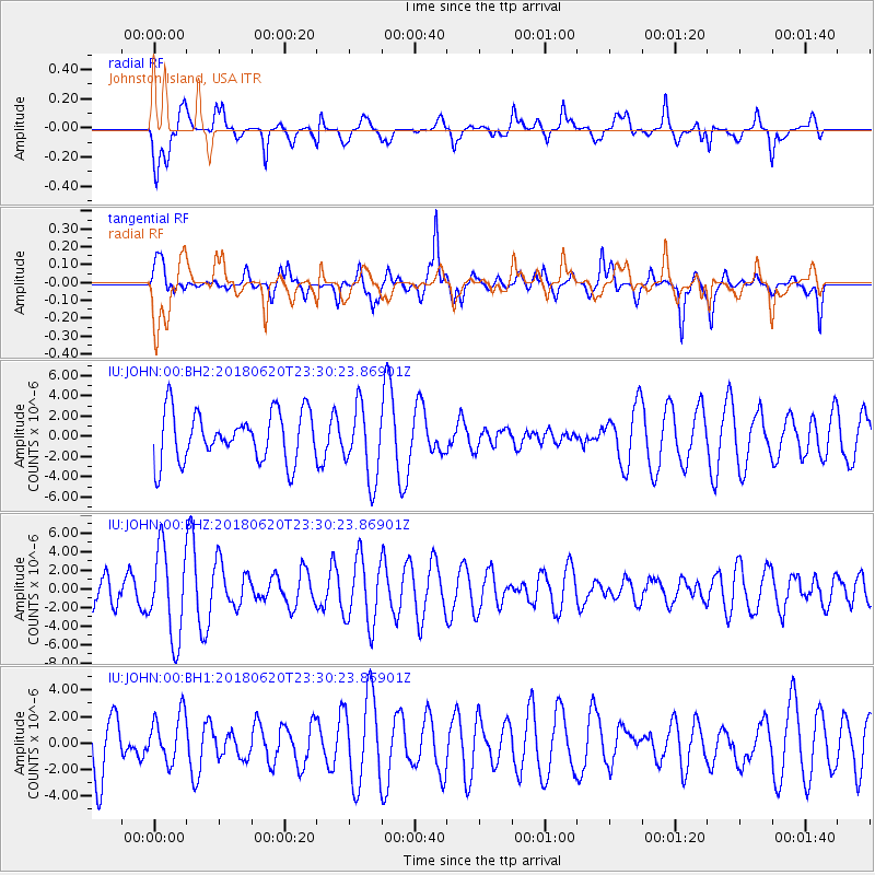
JOHN Johnston Island, USA - Earthquake Result Viewer
*The percent match for this event was below the threshold and hence no stack was calculated.
| Earthquake location: |
Tonga Islands Region |
| Earthquake latitude/longitude: |
-22.4/-175.1 |
| Earthquake time(UTC): |
2018/06/20 (171) 23:23:26 GMT |
| Earthquake Depth: |
14 km |
| Earthquake Magnitude: |
5.4 Mww |
| Earthquake Catalog/Contributor: |
NEIC PDE/us |
|
| Network: |
IU Global Seismograph Network (GSN - IRIS/USGS) |
| Station: |
JOHN Johnston Island, USA |
| Lat/Lon: |
16.73 N/169.53 W |
| Elevation: |
2.0 m |
|
| Distance: |
39.2 deg |
| Az: |
8.419 deg |
| Baz: |
188.131 deg |
| Ray Param: |
$rayparam |
*The percent match for this event was below the threshold and hence was not used in the summary stack. |
|
| Radial Match: |
73.13467 % |
| Radial Bump: |
400 |
| Transverse Match: |
51.97255 % |
| Transverse Bump: |
374 |
| SOD ConfigId: |
2750733 |
| Insert Time: |
2018-07-12 03:52:17.396 +0000 |
| GWidth: |
2.5 |
| Max Bumps: |
400 |
| Tol: |
0.001 |
|
Signal To Noise
| Channel | StoN | STA | LTA |
| IU:JOHN:00:BHZ:20180620T23:30:23.86901Z | 1.6331139 | 4.7609215E-6 | 2.9152416E-6 |
| IU:JOHN:00:BH1:20180620T23:30:23.86901Z | 0.8926541 | 1.8470018E-6 | 2.0691125E-6 |
| IU:JOHN:00:BH2:20180620T23:30:23.86901Z | 1.4864044 | 3.6015451E-6 | 2.4229914E-6 |
| Arrivals |
| Ps | |
| PpPs | |
| PsPs/PpSs | |


