You are here: Home > Network List > AK - Alaska Regional Network Stations List
> Station G24K Hadweenzic River, AK, USA > Earthquake Result Viewer
G24K Hadweenzic River, AK, USA - Earthquake Result Viewer
| Earthquake location: |
Luzon, Philippines |
| Earthquake latitude/longitude: |
14.1/119.4 |
| Earthquake time(UTC): |
2022/03/13 (072) 21:05:52 GMT |
| Earthquake Depth: |
33 km |
| Earthquake Magnitude: |
6.7 Mi |
| Earthquake Catalog/Contributor: |
NEIC PDE/pt |
|
| Network: |
AK Alaska Regional Network |
| Station: |
G24K Hadweenzic River, AK, USA |
| Lat/Lon: |
66.70 N/147.48 W |
| Elevation: |
503 m |
|
| Distance: |
78.4 deg |
| Az: |
23.919 deg |
| Baz: |
278.48 deg |
| Ray Param: |
0.049608897 |
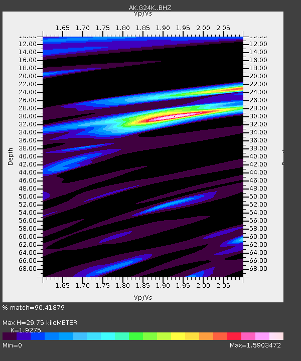
| Estimated Moho Depth: |
29.75 km |
| Estimated Crust Vp/Vs: |
1.93 |
| Assumed Crust Vp: |
6.522 km/s |
| Estimated Crust Vs: |
3.383 km/s |
| Estimated Crust Poisson's Ratio: |
0.32 |
|
| Radial Match: |
90.41879 % |
| Radial Bump: |
378 |
| Transverse Match: |
73.42146 % |
| Transverse Bump: |
400 |
| SOD ConfigId: |
26694651 |
| Insert Time: |
2022-03-27 21:11:45.426 +0000 |
| GWidth: |
2.5 |
| Max Bumps: |
400 |
| Tol: |
0.001 |
|

Signal To Noise
| Channel | StoN | STA | LTA |
| AK:G24K: :BHZ:20220313T21:17:18.340027Z | 3.3858752 | 5.686096E-7 | 1.6793578E-7 |
| AK:G24K: :BHN:20220313T21:17:18.340027Z | 1.7280812 | 2.550897E-7 | 1.4761441E-7 |
| AK:G24K: :BHE:20220313T21:17:18.340027Z | 2.1621687 | 3.2716193E-7 | 1.5131192E-7 |
| Arrivals |
| Ps | 4.4 SECOND |
| PpPs | 13 SECOND |
| PsPs/PpSs | 17 SECOND |


