You are here: Home > Network List > AK - Alaska Regional Network Stations List
> Station K20K Telida, AK, USA > Earthquake Result Viewer
K20K Telida, AK, USA - Earthquake Result Viewer
| Earthquake location: |
Luzon, Philippines |
| Earthquake latitude/longitude: |
14.1/119.4 |
| Earthquake time(UTC): |
2022/03/13 (072) 21:05:52 GMT |
| Earthquake Depth: |
33 km |
| Earthquake Magnitude: |
6.7 Mi |
| Earthquake Catalog/Contributor: |
NEIC PDE/pt |
|
| Network: |
AK Alaska Regional Network |
| Station: |
K20K Telida, AK, USA |
| Lat/Lon: |
63.36 N/154.07 W |
| Elevation: |
548 m |
|
| Distance: |
76.0 deg |
| Az: |
27.634 deg |
| Baz: |
273.328 deg |
| Ray Param: |
0.051256467 |
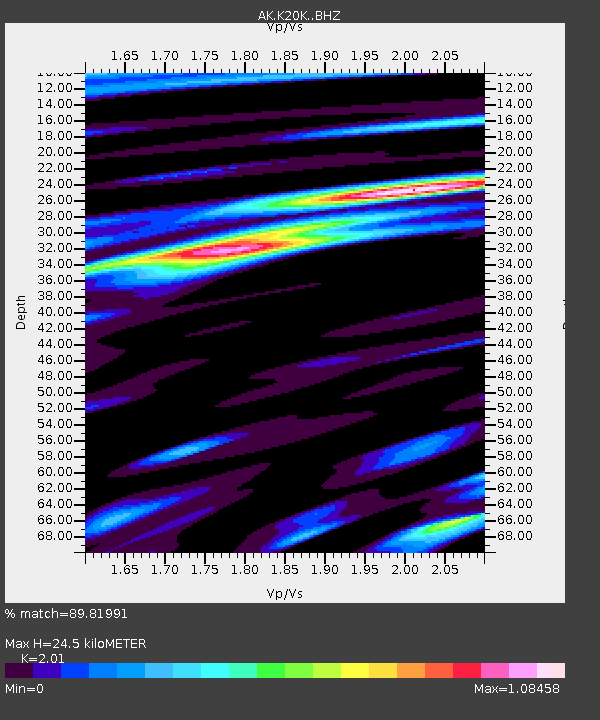
| Estimated Moho Depth: |
24.5 km |
| Estimated Crust Vp/Vs: |
2.01 |
| Assumed Crust Vp: |
6.438 km/s |
| Estimated Crust Vs: |
3.203 km/s |
| Estimated Crust Poisson's Ratio: |
0.34 |
|
| Radial Match: |
89.81991 % |
| Radial Bump: |
396 |
| Transverse Match: |
81.388596 % |
| Transverse Bump: |
400 |
| SOD ConfigId: |
26694651 |
| Insert Time: |
2022-03-27 21:12:29.597 +0000 |
| GWidth: |
2.5 |
| Max Bumps: |
400 |
| Tol: |
0.001 |
|

Signal To Noise
| Channel | StoN | STA | LTA |
| AK:K20K: :BHZ:20220313T21:17:04.700012Z | 7.225687 | 9.0131726E-7 | 1.2473792E-7 |
| AK:K20K: :BHN:20220313T21:17:04.700012Z | 3.1863244 | 3.5211917E-7 | 1.1050951E-7 |
| AK:K20K: :BHE:20220313T21:17:04.700012Z | 1.826576 | 3.453546E-7 | 1.8907213E-7 |
| Arrivals |
| Ps | 4.0 SECOND |
| PpPs | 11 SECOND |
| PsPs/PpSs | 15 SECOND |


