You are here: Home > Network List > AK - Alaska Regional Network Stations List
> Station P17K Kvichak River, AK, USA > Earthquake Result Viewer
P17K Kvichak River, AK, USA - Earthquake Result Viewer
| Earthquake location: |
Luzon, Philippines |
| Earthquake latitude/longitude: |
14.1/119.4 |
| Earthquake time(UTC): |
2022/03/13 (072) 21:05:52 GMT |
| Earthquake Depth: |
33 km |
| Earthquake Magnitude: |
6.7 Mi |
| Earthquake Catalog/Contributor: |
NEIC PDE/pt |
|
| Network: |
AK Alaska Regional Network |
| Station: |
P17K Kvichak River, AK, USA |
| Lat/Lon: |
59.20 N/156.44 W |
| Elevation: |
91 m |
|
| Distance: |
75.0 deg |
| Az: |
32.0 deg |
| Baz: |
272.345 deg |
| Ray Param: |
0.051885612 |
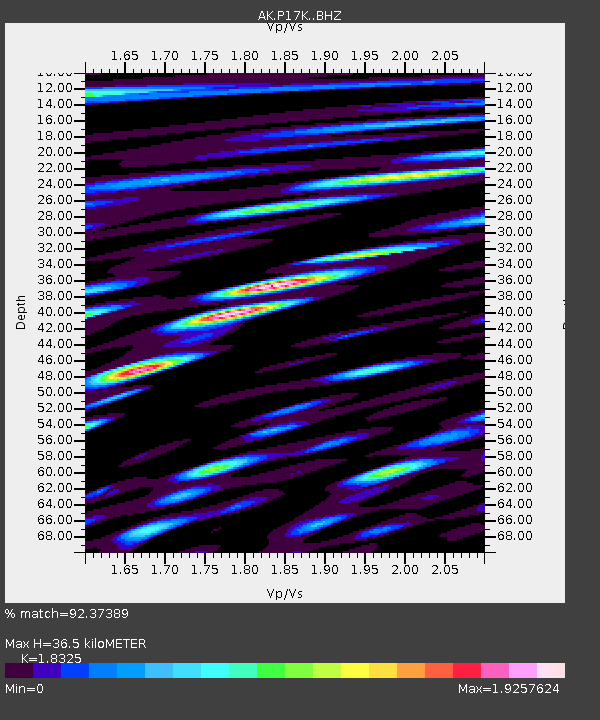
| Estimated Moho Depth: |
36.5 km |
| Estimated Crust Vp/Vs: |
1.83 |
| Assumed Crust Vp: |
6.276 km/s |
| Estimated Crust Vs: |
3.425 km/s |
| Estimated Crust Poisson's Ratio: |
0.29 |
|
| Radial Match: |
92.37389 % |
| Radial Bump: |
400 |
| Transverse Match: |
89.5561 % |
| Transverse Bump: |
400 |
| SOD ConfigId: |
26694651 |
| Insert Time: |
2022-03-27 21:13:24.393 +0000 |
| GWidth: |
2.5 |
| Max Bumps: |
400 |
| Tol: |
0.001 |
|

Signal To Noise
| Channel | StoN | STA | LTA |
| AK:P17K: :BHZ:20220313T21:16:59.340027Z | 12.436417 | 4.204361E-6 | 3.3806853E-7 |
| AK:P17K: :BHN:20220313T21:16:59.340027Z | 1.4246393 | 9.1324034E-7 | 6.4103267E-7 |
| AK:P17K: :BHE:20220313T21:16:59.340027Z | 3.2518415 | 1.688604E-6 | 5.192762E-7 |
| Arrivals |
| Ps | 5.0 SECOND |
| PpPs | 16 SECOND |
| PsPs/PpSs | 21 SECOND |


