You are here: Home > Network List > AV - Alaska Volcano Observatory Stations List
> Station SPCL Chakachamna Lake, Mount Spurr, Alaska > Earthquake Result Viewer
SPCL Chakachamna Lake, Mount Spurr, Alaska - Earthquake Result Viewer
| Earthquake location: |
Luzon, Philippines |
| Earthquake latitude/longitude: |
14.1/119.4 |
| Earthquake time(UTC): |
2022/03/13 (072) 21:05:52 GMT |
| Earthquake Depth: |
33 km |
| Earthquake Magnitude: |
6.7 Mi |
| Earthquake Catalog/Contributor: |
NEIC PDE/pt |
|
| Network: |
AV Alaska Volcano Observatory |
| Station: |
SPCL Chakachamna Lake, Mount Spurr, Alaska |
| Lat/Lon: |
61.20 N/152.34 W |
| Elevation: |
1274 m |
|
| Distance: |
77.0 deg |
| Az: |
29.796 deg |
| Baz: |
275.364 deg |
| Ray Param: |
0.05060326 |
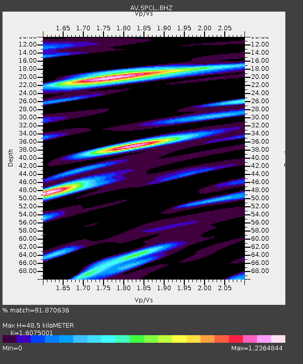
| Estimated Moho Depth: |
48.5 km |
| Estimated Crust Vp/Vs: |
1.61 |
| Assumed Crust Vp: |
6.566 km/s |
| Estimated Crust Vs: |
4.085 km/s |
| Estimated Crust Poisson's Ratio: |
0.18 |
|
| Radial Match: |
91.870636 % |
| Radial Bump: |
400 |
| Transverse Match: |
82.448784 % |
| Transverse Bump: |
400 |
| SOD ConfigId: |
26694651 |
| Insert Time: |
2022-03-27 21:17:40.944 +0000 |
| GWidth: |
2.5 |
| Max Bumps: |
400 |
| Tol: |
0.001 |
|

Signal To Noise
| Channel | StoN | STA | LTA |
| AV:SPCL: :BHZ:20220313T21:17:10.179993Z | 7.3599257 | 1.1213408E-6 | 1.5235761E-7 |
| AV:SPCL: :BHN:20220313T21:17:10.179993Z | 1.0180503 | 1.5093077E-7 | 1.4825473E-7 |
| AV:SPCL: :BHE:20220313T21:17:10.179993Z | 1.5375078 | 2.3119397E-7 | 1.503693E-7 |
| Arrivals |
| Ps | 4.7 SECOND |
| PpPs | 19 SECOND |
| PsPs/PpSs | 23 SECOND |


