You are here: Home > Network List > AV - Alaska Volcano Observatory Stations List
> Station SPCR Ckakachatna River, Mount Spurr, Alaska > Earthquake Result Viewer
SPCR Ckakachatna River, Mount Spurr, Alaska - Earthquake Result Viewer
| Earthquake location: |
Luzon, Philippines |
| Earthquake latitude/longitude: |
14.1/119.4 |
| Earthquake time(UTC): |
2022/03/13 (072) 21:05:52 GMT |
| Earthquake Depth: |
33 km |
| Earthquake Magnitude: |
6.7 Mi |
| Earthquake Catalog/Contributor: |
NEIC PDE/pt |
|
| Network: |
AV Alaska Volcano Observatory |
| Station: |
SPCR Ckakachatna River, Mount Spurr, Alaska |
| Lat/Lon: |
61.20 N/152.21 W |
| Elevation: |
984 m |
|
| Distance: |
77.0 deg |
| Az: |
29.785 deg |
| Baz: |
275.476 deg |
| Ray Param: |
0.050561458 |
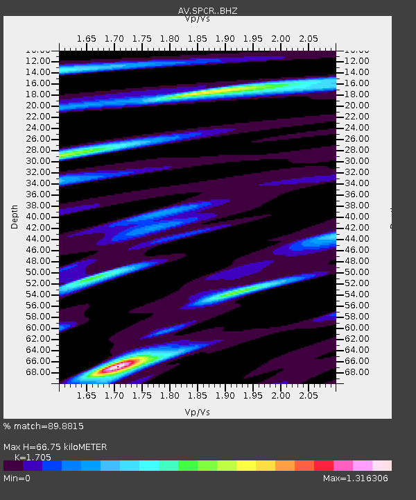
| Estimated Moho Depth: |
66.75 km |
| Estimated Crust Vp/Vs: |
1.71 |
| Assumed Crust Vp: |
6.566 km/s |
| Estimated Crust Vs: |
3.851 km/s |
| Estimated Crust Poisson's Ratio: |
0.24 |
|
| Radial Match: |
89.8815 % |
| Radial Bump: |
400 |
| Transverse Match: |
80.66859 % |
| Transverse Bump: |
400 |
| SOD ConfigId: |
26694651 |
| Insert Time: |
2022-03-27 21:17:42.847 +0000 |
| GWidth: |
2.5 |
| Max Bumps: |
400 |
| Tol: |
0.001 |
|

Signal To Noise
| Channel | StoN | STA | LTA |
| AV:SPCR: :BHZ:20220313T21:17:10.539001Z | 10.754691 | 1.6493073E-6 | 1.5335702E-7 |
| AV:SPCR: :BHN:20220313T21:17:10.539001Z | 1.5123742 | 3.3241759E-7 | 2.1979851E-7 |
| AV:SPCR: :BHE:20220313T21:17:10.539001Z | 4.246496 | 6.255634E-7 | 1.4731285E-7 |
| Arrivals |
| Ps | 7.4 SECOND |
| PpPs | 27 SECOND |
| PsPs/PpSs | 34 SECOND |


