You are here: Home > Network List > G - GEOSCOPE Stations List
> Station MPG Montagne des Peres, French Guyana > Earthquake Result Viewer
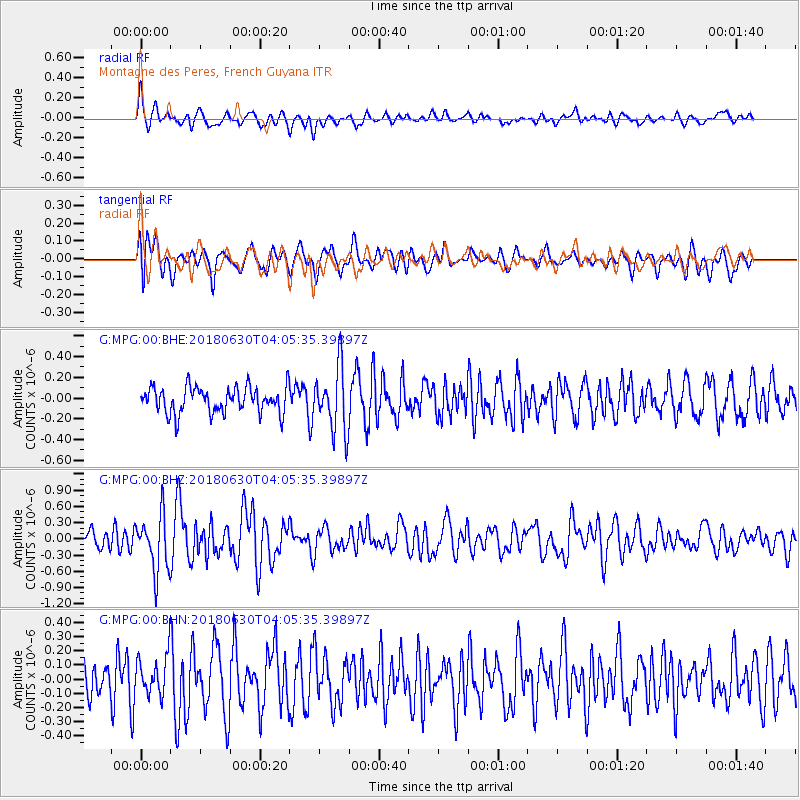
MPG Montagne des Peres, French Guyana - Earthquake Result Viewer
*The percent match for this event was below the threshold and hence no stack was calculated.
| Earthquake location: |
Near Coast Of Jalisco, Mexico |
| Earthquake latitude/longitude: |
19.1/-105.1 |
| Earthquake time(UTC): |
2018/06/30 (181) 03:56:50 GMT |
| Earthquake Depth: |
15 km |
| Earthquake Magnitude: |
5.9 Mww |
| Earthquake Catalog/Contributor: |
NEIC PDE/us |
|
| Network: |
G GEOSCOPE |
| Station: |
MPG Montagne des Peres, French Guyana |
| Lat/Lon: |
5.11 N/52.64 W |
| Elevation: |
147 m |
|
| Distance: |
52.9 deg |
| Az: |
98.163 deg |
| Baz: |
289.961 deg |
| Ray Param: |
$rayparam |
*The percent match for this event was below the threshold and hence was not used in the summary stack. |
|
| Radial Match: |
61.854717 % |
| Radial Bump: |
400 |
| Transverse Match: |
57.58671 % |
| Transverse Bump: |
400 |
| SOD ConfigId: |
2752131 |
| Insert Time: |
2018-07-14 03:57:46.376 +0000 |
| GWidth: |
2.5 |
| Max Bumps: |
400 |
| Tol: |
0.001 |
|
Signal To Noise
| Channel | StoN | STA | LTA |
| G:MPG:00:BHZ:20180630T04:05:35.39897Z | 3.1421926 | 5.1728324E-7 | 1.6462492E-7 |
| G:MPG:00:BHN:20180630T04:05:35.39897Z | 1.162355 | 1.3888253E-7 | 1.1948376E-7 |
| G:MPG:00:BHE:20180630T04:05:35.39897Z | 2.452035 | 3.0724706E-7 | 1.2530289E-7 |
| Arrivals |
| Ps | |
| PpPs | |
| PsPs/PpSs | |


