You are here: Home > Network List > G - GEOSCOPE Stations List
> Station FOMA Nahampoana reservation, Fort Dauphin, Madagascar > Earthquake Result Viewer
FOMA Nahampoana reservation, Fort Dauphin, Madagascar - Earthquake Result Viewer
| Earthquake location: |
Southern Sumatra, Indonesia |
| Earthquake latitude/longitude: |
-0.7/98.6 |
| Earthquake time(UTC): |
2022/03/13 (072) 21:09:21 GMT |
| Earthquake Depth: |
22 km |
| Earthquake Magnitude: |
6.7 Mww |
| Earthquake Catalog/Contributor: |
NEIC PDE/us |
|
| Network: |
G GEOSCOPE |
| Station: |
FOMA Nahampoana reservation, Fort Dauphin, Madagascar |
| Lat/Lon: |
24.98 S/46.98 E |
| Elevation: |
26 m |
|
| Distance: |
55.4 deg |
| Az: |
239.842 deg |
| Baz: |
72.297 deg |
| Ray Param: |
0.064798914 |
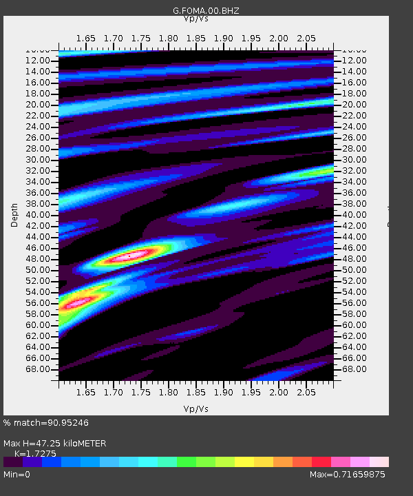
| Estimated Moho Depth: |
47.25 km |
| Estimated Crust Vp/Vs: |
1.73 |
| Assumed Crust Vp: |
6.183 km/s |
| Estimated Crust Vs: |
3.579 km/s |
| Estimated Crust Poisson's Ratio: |
0.25 |
|
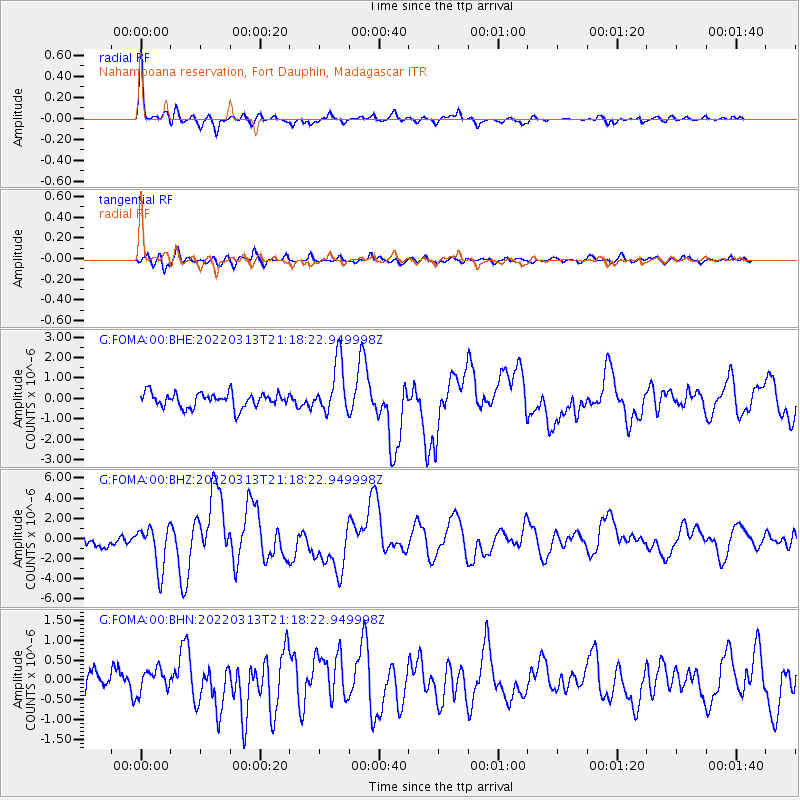
| Radial Match: |
90.95246 % |
| Radial Bump: |
393 |
| Transverse Match: |
74.8877 % |
| Transverse Bump: |
400 |
| SOD ConfigId: |
26694651 |
| Insert Time: |
2022-03-27 21:32:48.512 +0000 |
| GWidth: |
2.5 |
| Max Bumps: |
400 |
| Tol: |
0.001 |
|
Signal To Noise
| Channel | StoN | STA | LTA |
| G:FOMA:00:BHZ:20220313T21:18:22.949998Z | 1.9860384 | 2.1332999E-6 | 1.0741484E-6 |
| G:FOMA:00:BHN:20220313T21:18:22.949998Z | 0.8388708 | 2.8873814E-7 | 3.4419858E-7 |
| G:FOMA:00:BHE:20220313T21:18:22.949998Z | 3.5726743 | 1.2710564E-6 | 3.557717E-7 |
| Arrivals |
| Ps | 5.8 SECOND |
| PpPs | 20 SECOND |
| PsPs/PpSs | 26 SECOND |


