You are here: Home > Network List > IU - Global Seismograph Network (GSN - IRIS/USGS) Stations List
> Station XMAS Kiritimati Island, Republic of Kiribati > Earthquake Result Viewer
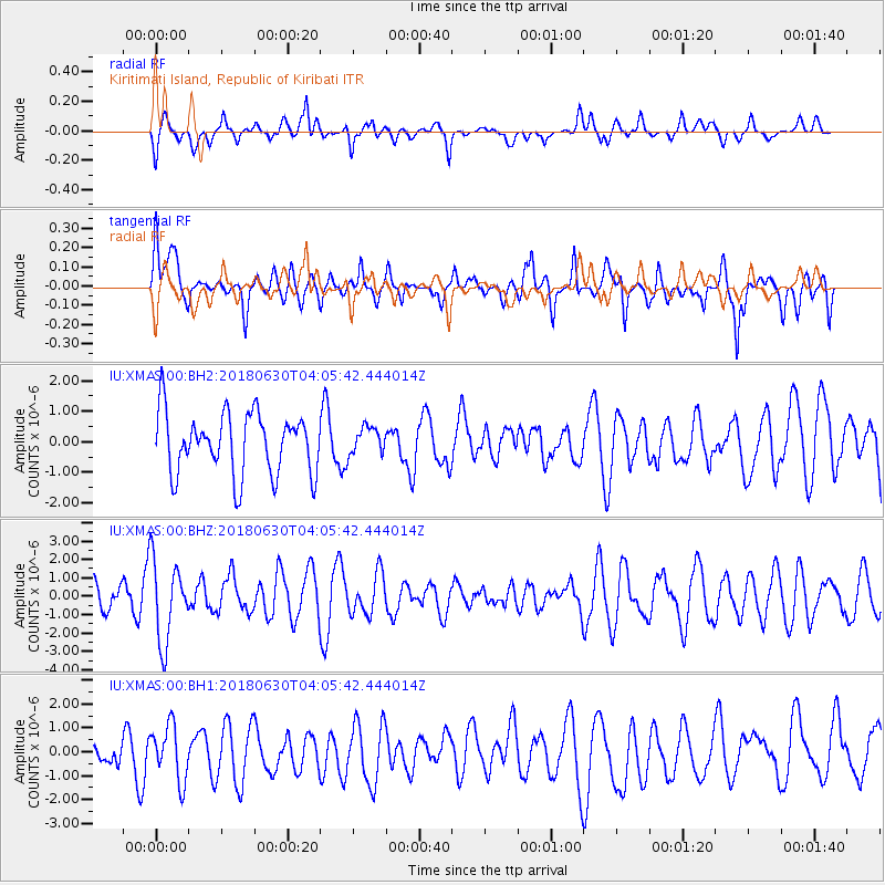
XMAS Kiritimati Island, Republic of Kiribati - Earthquake Result Viewer
*The percent match for this event was below the threshold and hence no stack was calculated.
| Earthquake location: |
Near Coast Of Jalisco, Mexico |
| Earthquake latitude/longitude: |
19.1/-105.1 |
| Earthquake time(UTC): |
2018/06/30 (181) 03:56:50 GMT |
| Earthquake Depth: |
15 km |
| Earthquake Magnitude: |
5.9 Mww |
| Earthquake Catalog/Contributor: |
NEIC PDE/us |
|
| Network: |
IU Global Seismograph Network (GSN - IRIS/USGS) |
| Station: |
XMAS Kiritimati Island, Republic of Kiribati |
| Lat/Lon: |
2.04 N/157.45 W |
| Elevation: |
20 m |
|
| Distance: |
53.9 deg |
| Az: |
258.234 deg |
| Baz: |
67.901 deg |
| Ray Param: |
$rayparam |
*The percent match for this event was below the threshold and hence was not used in the summary stack. |
|
| Radial Match: |
40.800762 % |
| Radial Bump: |
400 |
| Transverse Match: |
58.99169 % |
| Transverse Bump: |
400 |
| SOD ConfigId: |
2752131 |
| Insert Time: |
2018-07-14 03:58:58.255 +0000 |
| GWidth: |
2.5 |
| Max Bumps: |
400 |
| Tol: |
0.001 |
|
Signal To Noise
| Channel | StoN | STA | LTA |
| IU:XMAS:00:BHZ:20180630T04:05:42.444014Z | 2.8052135 | 2.2077404E-6 | 7.870134E-7 |
| IU:XMAS:00:BH1:20180630T04:05:42.444014Z | 1.3608721 | 1.1485788E-6 | 8.4400205E-7 |
| IU:XMAS:00:BH2:20180630T04:05:42.444014Z | 0.45009688 | 4.5145998E-7 | 1.0030284E-6 |
| Arrivals |
| Ps | |
| PpPs | |
| PsPs/PpSs | |


