You are here: Home > Network List > AV - Alaska Volcano Observatory Stations List
> Station MAPS Pakushin Southeast, Makushin Volcano, Alaska > Earthquake Result Viewer
MAPS Pakushin Southeast, Makushin Volcano, Alaska - Earthquake Result Viewer
| Earthquake location: |
Java, Indonesia |
| Earthquake latitude/longitude: |
-7.6/107.0 |
| Earthquake time(UTC): |
2022/03/16 (075) 03:00:03 GMT |
| Earthquake Depth: |
51 km |
| Earthquake Magnitude: |
5.3 Mww |
| Earthquake Catalog/Contributor: |
NEIC PDE/us |
|
| Network: |
AV Alaska Volcano Observatory |
| Station: |
MAPS Pakushin Southeast, Makushin Volcano, Alaska |
| Lat/Lon: |
53.81 N/166.94 W |
| Elevation: |
333 m |
|
| Distance: |
93.8 deg |
| Az: |
36.364 deg |
| Baz: |
262.3 deg |
| Ray Param: |
0.041175343 |
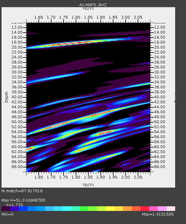
| Estimated Moho Depth: |
51.0 km |
| Estimated Crust Vp/Vs: |
1.73 |
| Assumed Crust Vp: |
3.943 km/s |
| Estimated Crust Vs: |
2.286 km/s |
| Estimated Crust Poisson's Ratio: |
0.25 |
|
| Radial Match: |
97.917816 % |
| Radial Bump: |
107 |
| Transverse Match: |
97.91137 % |
| Transverse Bump: |
117 |
| SOD ConfigId: |
27527651 |
| Insert Time: |
2022-03-30 03:02:12.619 +0000 |
| GWidth: |
2.5 |
| Max Bumps: |
400 |
| Tol: |
0.001 |
|
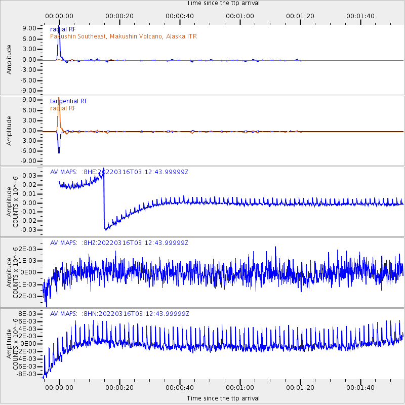
Signal To Noise
| Channel | StoN | STA | LTA |
| AV:MAPS: :BHZ:20220316T03:12:43.99999Z | 0.36736542 | 1.1358029E-9 | 3.0917524E-9 |
| AV:MAPS: :BHN:20220316T03:12:43.99999Z | 0.40620428 | 7.1061144E-9 | 1.7493942E-8 |
| AV:MAPS: :BHE:20220316T03:12:43.99999Z | 0.38246155 | 7.964791E-9 | 2.0825077E-8 |
| Arrivals |
| Ps | 9.4 SECOND |
| PpPs | 35 SECOND |
| PsPs/PpSs | 44 SECOND |


