You are here: Home > Network List > XE05 - Sierra Nevada EarthScope Project- EarthScope Flex Array Stations List
> Station SNP95 SNP95 > Earthquake Result Viewer
SNP95 SNP95 - Earthquake Result Viewer
| Earthquake location: |
New Ireland Region, P.N.G. |
| Earthquake latitude/longitude: |
-4.5/153.5 |
| Earthquake time(UTC): |
2005/09/09 (252) 07:26:43 GMT |
| Earthquake Depth: |
90 km |
| Earthquake Magnitude: |
6.3 MB, 7.7 MW, 7.5 MW |
| Earthquake Catalog/Contributor: |
WHDF/NEIC |
|
| Network: |
XE Sierra Nevada EarthScope Project- EarthScope Flex Array |
| Station: |
SNP95 SNP95 |
| Lat/Lon: |
38.33 N/120.25 W |
| Elevation: |
1754 m |
|
| Distance: |
89.9 deg |
| Az: |
51.7 deg |
| Baz: |
264.155 deg |
| Ray Param: |
0.04169726 |
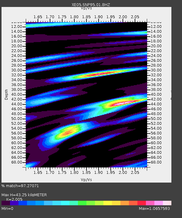
| Estimated Moho Depth: |
43.25 km |
| Estimated Crust Vp/Vs: |
2.01 |
| Assumed Crust Vp: |
6.597 km/s |
| Estimated Crust Vs: |
3.291 km/s |
| Estimated Crust Poisson's Ratio: |
0.33 |
|
| Radial Match: |
97.27071 % |
| Radial Bump: |
400 |
| Transverse Match: |
93.58503 % |
| Transverse Bump: |
400 |
| SOD ConfigId: |
268666 |
| Insert Time: |
2010-03-09 17:29:49.499 +0000 |
| GWidth: |
2.5 |
| Max Bumps: |
400 |
| Tol: |
0.001 |
|

Signal To Noise
| Channel | StoN | STA | LTA |
| XE:SNP95:01:BHZ:20050909T07:39:01.334004Z | 15.199437 | 1.0904539E-6 | 7.1743045E-8 |
| XE:SNP95:01:BHN:20050909T07:39:01.334004Z | 1.9694798 | 1.0466211E-7 | 5.3142006E-8 |
| XE:SNP95:01:BHE:20050909T07:39:01.334004Z | 7.6997595 | 3.685891E-7 | 4.7870213E-8 |
| Arrivals |
| Ps | 6.7 SECOND |
| PpPs | 19 SECOND |
| PsPs/PpSs | 26 SECOND |


