You are here: Home > Network List > CN - Canadian National Seismograph Network Stations List
> Station INK INUVIK, NT > Earthquake Result Viewer
INK INUVIK, NT - Earthquake Result Viewer
*The percent match for this event was below the threshold and hence no stack was calculated.
| Earthquake location: |
Near East Coast Of Honshu, Japan |
| Earthquake latitude/longitude: |
37.7/141.7 |
| Earthquake time(UTC): |
2022/03/16 (075) 14:34:26 GMT |
| Earthquake Depth: |
48 km |
| Earthquake Magnitude: |
6.0 mwb |
| Earthquake Catalog/Contributor: |
NEIC PDE/us |
|
| Network: |
CN Canadian National Seismograph Network |
| Station: |
INK INUVIK, NT |
| Lat/Lon: |
68.31 N/133.53 W |
| Elevation: |
44 m |
|
| Distance: |
53.7 deg |
| Az: |
27.345 deg |
| Baz: |
281.436 deg |
| Ray Param: |
$rayparam |
*The percent match for this event was below the threshold and hence was not used in the summary stack. |
|
| Radial Match: |
64.52928 % |
| Radial Bump: |
378 |
| Transverse Match: |
58.74934 % |
| Transverse Bump: |
400 |
| SOD ConfigId: |
27527651 |
| Insert Time: |
2022-03-30 14:49:37.498 +0000 |
| GWidth: |
2.5 |
| Max Bumps: |
400 |
| Tol: |
0.001 |
|
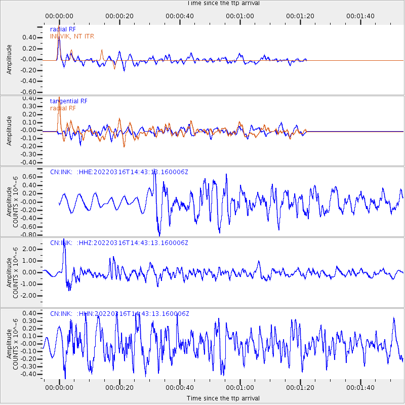
Signal To Noise
| Channel | StoN | STA | LTA |
| CN:INK: :HHZ:20220316T14:43:13.160006Z | 8.625797 | 1.0850151E-6 | 1.2578724E-7 |
| CN:INK: :HHN:20220316T14:43:13.160006Z | 2.8996189 | 1.9599318E-7 | 6.759274E-8 |
| CN:INK: :HHE:20220316T14:43:13.160006Z | 3.6781487 | 4.5090303E-7 | 1.2258967E-7 |
| Arrivals |
| Ps | |
| PpPs | |
| PsPs/PpSs | |


