You are here: Home > Network List > US - United States National Seismic Network Stations List
> Station MNTX Cornudas Mountains, Texas, USA > Earthquake Result Viewer
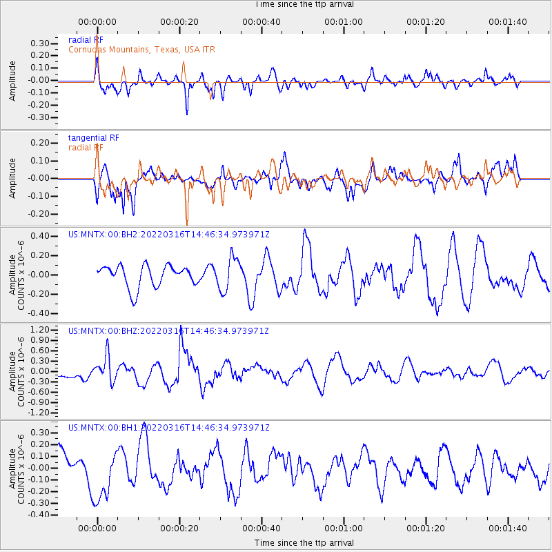
MNTX Cornudas Mountains, Texas, USA - Earthquake Result Viewer
*The percent match for this event was below the threshold and hence no stack was calculated.
| Earthquake location: |
Near East Coast Of Honshu, Japan |
| Earthquake latitude/longitude: |
37.7/141.7 |
| Earthquake time(UTC): |
2022/03/16 (075) 14:34:26 GMT |
| Earthquake Depth: |
48 km |
| Earthquake Magnitude: |
6.0 mwb |
| Earthquake Catalog/Contributor: |
NEIC PDE/us |
|
| Network: |
US United States National Seismic Network |
| Station: |
MNTX Cornudas Mountains, Texas, USA |
| Lat/Lon: |
31.70 N/105.38 W |
| Elevation: |
405 m |
|
| Distance: |
86.9 deg |
| Az: |
51.817 deg |
| Baz: |
312.983 deg |
| Ray Param: |
$rayparam |
*The percent match for this event was below the threshold and hence was not used in the summary stack. |
|
| Radial Match: |
61.77544 % |
| Radial Bump: |
400 |
| Transverse Match: |
58.355846 % |
| Transverse Bump: |
338 |
| SOD ConfigId: |
27527651 |
| Insert Time: |
2022-03-30 15:08:46.382 +0000 |
| GWidth: |
2.5 |
| Max Bumps: |
400 |
| Tol: |
0.001 |
|
Signal To Noise
| Channel | StoN | STA | LTA |
| US:MNTX:00:BHZ:20220316T14:46:34.973971Z | 2.1627223 | 3.7533303E-7 | 1.7354657E-7 |
| US:MNTX:00:BH1:20220316T14:46:34.973971Z | 1.609321 | 2.2761321E-7 | 1.4143431E-7 |
| US:MNTX:00:BH2:20220316T14:46:34.973971Z | 1.595605 | 1.779245E-7 | 1.1150912E-7 |
| Arrivals |
| Ps | |
| PpPs | |
| PsPs/PpSs | |


