You are here: Home > Network List > UW - Pacific Northwest Regional Seismic Network Stations List
> Station HOOD Mt Hood Meadows, OR CREST BB SMO > Earthquake Result Viewer
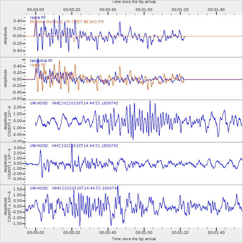
HOOD Mt Hood Meadows, OR CREST BB SMO - Earthquake Result Viewer
*The percent match for this event was below the threshold and hence no stack was calculated.
| Earthquake location: |
Near East Coast Of Honshu, Japan |
| Earthquake latitude/longitude: |
37.7/141.7 |
| Earthquake time(UTC): |
2022/03/16 (075) 14:34:26 GMT |
| Earthquake Depth: |
48 km |
| Earthquake Magnitude: |
6.0 mwb |
| Earthquake Catalog/Contributor: |
NEIC PDE/us |
|
| Network: |
UW Pacific Northwest Regional Seismic Network |
| Station: |
HOOD Mt Hood Meadows, OR CREST BB SMO |
| Lat/Lon: |
45.32 N/121.65 W |
| Elevation: |
1520 m |
|
| Distance: |
68.5 deg |
| Az: |
48.854 deg |
| Baz: |
302.139 deg |
| Ray Param: |
$rayparam |
*The percent match for this event was below the threshold and hence was not used in the summary stack. |
|
| Radial Match: |
69.40753 % |
| Radial Bump: |
400 |
| Transverse Match: |
62.798397 % |
| Transverse Bump: |
400 |
| SOD ConfigId: |
27527651 |
| Insert Time: |
2022-03-30 15:09:59.587 +0000 |
| GWidth: |
2.5 |
| Max Bumps: |
400 |
| Tol: |
0.001 |
|
Signal To Noise
| Channel | StoN | STA | LTA |
| UW:HOOD: :HHZ:20220316T14:44:53.189974Z | 2.4548595 | 1.137858E-6 | 4.635125E-7 |
| UW:HOOD: :HHN:20220316T14:44:53.189974Z | 2.1442323 | 5.699091E-7 | 2.65787E-7 |
| UW:HOOD: :HHE:20220316T14:44:53.189974Z | 1.509916 | 7.871324E-7 | 5.213088E-7 |
| Arrivals |
| Ps | |
| PpPs | |
| PsPs/PpSs | |


