You are here: Home > Network List > AV - Alaska Volcano Observatory Stations List
> Station P19K Oil Pt, AK, USA > Earthquake Result Viewer
P19K Oil Pt, AK, USA - Earthquake Result Viewer
| Earthquake location: |
Near East Coast Of Honshu, Japan |
| Earthquake latitude/longitude: |
37.7/141.6 |
| Earthquake time(UTC): |
2022/03/16 (075) 14:36:33 GMT |
| Earthquake Depth: |
63 km |
| Earthquake Magnitude: |
7.3 mww |
| Earthquake Catalog/Contributor: |
NEIC PDE/us |
|
| Network: |
AV Alaska Volcano Observatory |
| Station: |
P19K Oil Pt, AK, USA |
| Lat/Lon: |
59.65 N/153.23 W |
| Elevation: |
629 m |
|
| Distance: |
46.1 deg |
| Az: |
39.781 deg |
| Baz: |
271.782 deg |
| Ray Param: |
0.07070195 |
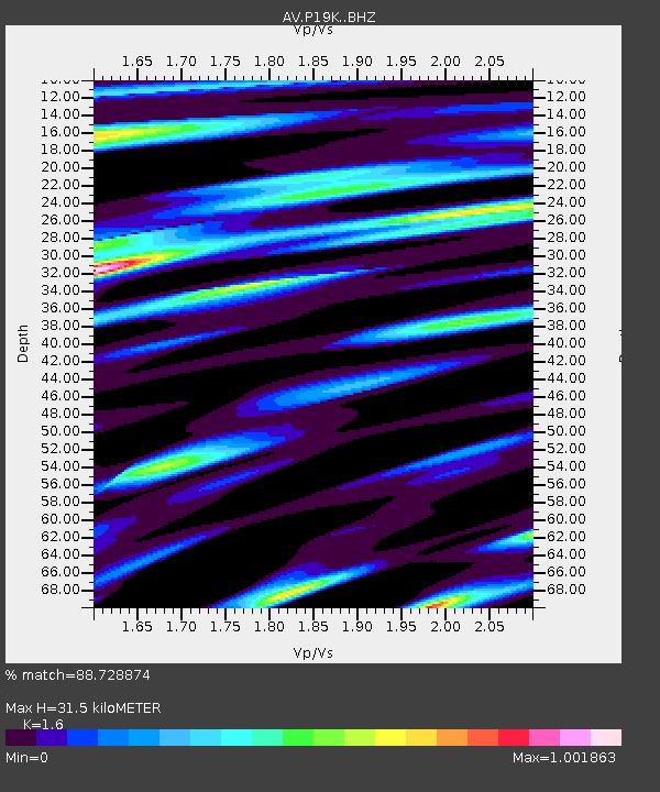
| Estimated Moho Depth: |
31.5 km |
| Estimated Crust Vp/Vs: |
1.60 |
| Assumed Crust Vp: |
5.989 km/s |
| Estimated Crust Vs: |
3.743 km/s |
| Estimated Crust Poisson's Ratio: |
0.18 |
|
| Radial Match: |
88.728874 % |
| Radial Bump: |
400 |
| Transverse Match: |
83.6634 % |
| Transverse Bump: |
400 |
| SOD ConfigId: |
27527651 |
| Insert Time: |
2022-03-30 15:21:53.551 +0000 |
| GWidth: |
2.5 |
| Max Bumps: |
400 |
| Tol: |
0.001 |
|

Signal To Noise
| Channel | StoN | STA | LTA |
| AV:P19K: :BHZ:20220316T14:44:20.450005Z | 11.230237 | 1.0515582E-5 | 9.363633E-7 |
| AV:P19K: :BHN:20220316T14:44:20.450005Z | 1.4373261 | 1.232306E-6 | 8.5736E-7 |
| AV:P19K: :BHE:20220316T14:44:20.450005Z | 7.6098824 | 3.8324956E-6 | 5.036208E-7 |
| Arrivals |
| Ps | 3.4 SECOND |
| PpPs | 13 SECOND |
| PsPs/PpSs | 16 SECOND |


