You are here: Home > Network List > AV - Alaska Volcano Observatory Stations List
> Station SPWE Spurr West, Mount Spurr, Alaska > Earthquake Result Viewer
SPWE Spurr West, Mount Spurr, Alaska - Earthquake Result Viewer
| Earthquake location: |
Near East Coast Of Honshu, Japan |
| Earthquake latitude/longitude: |
37.7/141.6 |
| Earthquake time(UTC): |
2022/03/16 (075) 14:36:33 GMT |
| Earthquake Depth: |
63 km |
| Earthquake Magnitude: |
7.3 mww |
| Earthquake Catalog/Contributor: |
NEIC PDE/us |
|
| Network: |
AV Alaska Volcano Observatory |
| Station: |
SPWE Spurr West, Mount Spurr, Alaska |
| Lat/Lon: |
61.27 N/152.56 W |
| Elevation: |
1317 m |
|
| Distance: |
46.4 deg |
| Az: |
37.519 deg |
| Baz: |
270.801 deg |
| Ray Param: |
0.07050676 |
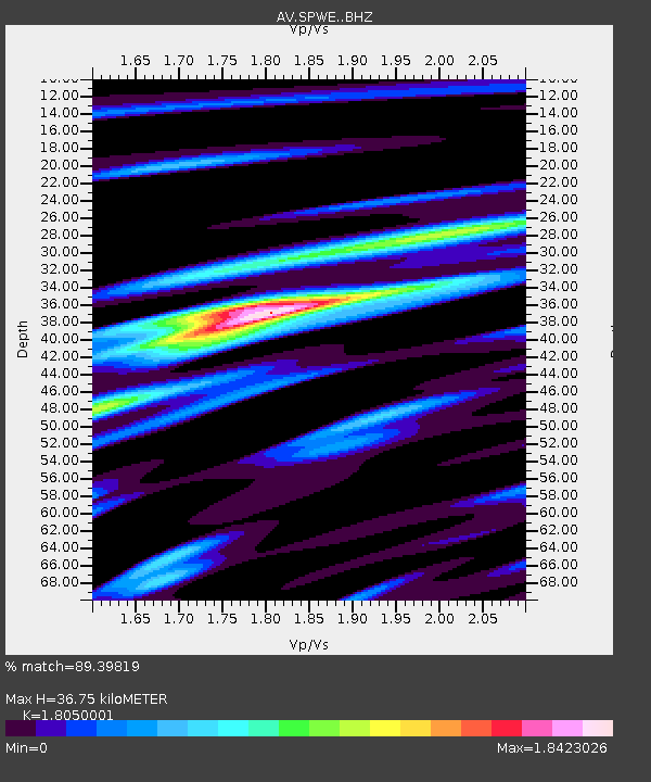
| Estimated Moho Depth: |
36.75 km |
| Estimated Crust Vp/Vs: |
1.81 |
| Assumed Crust Vp: |
6.566 km/s |
| Estimated Crust Vs: |
3.638 km/s |
| Estimated Crust Poisson's Ratio: |
0.28 |
|
| Radial Match: |
89.39819 % |
| Radial Bump: |
400 |
| Transverse Match: |
89.075066 % |
| Transverse Bump: |
400 |
| SOD ConfigId: |
27527651 |
| Insert Time: |
2022-03-30 15:22:16.925 +0000 |
| GWidth: |
2.5 |
| Max Bumps: |
400 |
| Tol: |
0.001 |
|

Signal To Noise
| Channel | StoN | STA | LTA |
| AV:SPWE: :BHZ:20220316T14:44:22.779991Z | 18.587751 | 3.224881E-6 | 1.7349497E-7 |
| AV:SPWE: :BHN:20220316T14:44:22.779991Z | 1.9080058 | 3.4406352E-7 | 1.8032624E-7 |
| AV:SPWE: :BHE:20220316T14:44:22.779991Z | 15.185569 | 2.1066978E-6 | 1.3873026E-7 |
| Arrivals |
| Ps | 4.8 SECOND |
| PpPs | 15 SECOND |
| PsPs/PpSs | 20 SECOND |


