You are here: Home > Network List > AV - Alaska Volcano Observatory Stations List
> Station OKTU Mount Tulik, Okmok Caldera, Alaska > Earthquake Result Viewer
OKTU Mount Tulik, Okmok Caldera, Alaska - Earthquake Result Viewer
| Earthquake location: |
Near East Coast Of Honshu, Japan |
| Earthquake latitude/longitude: |
37.7/141.6 |
| Earthquake time(UTC): |
2022/03/16 (075) 14:36:33 GMT |
| Earthquake Depth: |
63 km |
| Earthquake Magnitude: |
7.3 mww |
| Earthquake Catalog/Contributor: |
NEIC PDE/us |
|
| Network: |
AV Alaska Volcano Observatory |
| Station: |
OKTU Mount Tulik, Okmok Caldera, Alaska |
| Lat/Lon: |
53.38 N/168.04 W |
| Elevation: |
646 m |
|
| Distance: |
37.8 deg |
| Az: |
48.903 deg |
| Baz: |
266.226 deg |
| Ray Param: |
0.07577891 |
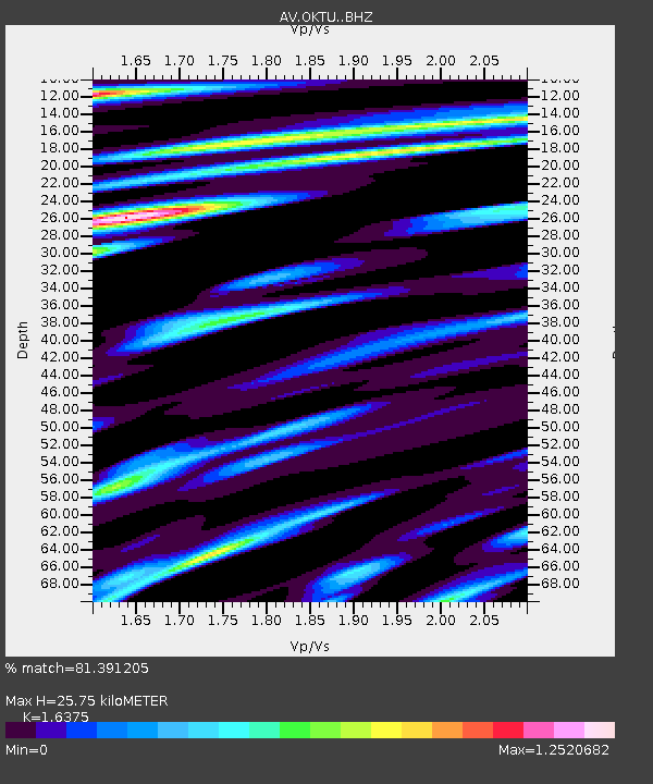
| Estimated Moho Depth: |
25.75 km |
| Estimated Crust Vp/Vs: |
1.64 |
| Assumed Crust Vp: |
5.88 km/s |
| Estimated Crust Vs: |
3.591 km/s |
| Estimated Crust Poisson's Ratio: |
0.20 |
|
| Radial Match: |
81.391205 % |
| Radial Bump: |
400 |
| Transverse Match: |
62.13512 % |
| Transverse Bump: |
400 |
| SOD ConfigId: |
27527651 |
| Insert Time: |
2022-03-30 15:22:46.823 +0000 |
| GWidth: |
2.5 |
| Max Bumps: |
400 |
| Tol: |
0.001 |
|

Signal To Noise
| Channel | StoN | STA | LTA |
| AV:OKTU: :BHZ:20220316T14:43:12.700005Z | 3.1612666 | 4.121871E-6 | 1.303867E-6 |
| AV:OKTU: :BHN:20220316T14:43:12.700005Z | 1.8153806 | 2.0370012E-6 | 1.1220794E-6 |
| AV:OKTU: :BHE:20220316T14:43:12.700005Z | 0.7815927 | 2.3071846E-6 | 2.9519015E-6 |
| Arrivals |
| Ps | 3.0 SECOND |
| PpPs | 11 SECOND |
| PsPs/PpSs | 14 SECOND |


