You are here: Home > Network List > BC - Red Sismica del Noroeste de Mexico Stations List
> Station PIX Pinacate, , SON, MEXICO > Earthquake Result Viewer
PIX Pinacate, , SON, MEXICO - Earthquake Result Viewer
| Earthquake location: |
Near East Coast Of Honshu, Japan |
| Earthquake latitude/longitude: |
37.7/141.6 |
| Earthquake time(UTC): |
2022/03/16 (075) 14:36:33 GMT |
| Earthquake Depth: |
63 km |
| Earthquake Magnitude: |
7.3 mww |
| Earthquake Catalog/Contributor: |
NEIC PDE/us |
|
| Network: |
BC Red Sismica del Noroeste de Mexico |
| Station: |
PIX Pinacate, , SON, MEXICO |
| Lat/Lon: |
31.56 N/113.46 W |
| Elevation: |
78 m |
|
| Distance: |
81.8 deg |
| Az: |
56.431 deg |
| Baz: |
309.265 deg |
| Ray Param: |
0.04720572 |
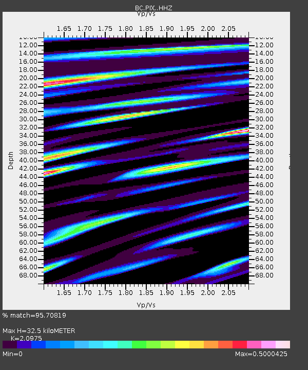
| Estimated Moho Depth: |
32.5 km |
| Estimated Crust Vp/Vs: |
2.10 |
| Assumed Crust Vp: |
6.276 km/s |
| Estimated Crust Vs: |
2.992 km/s |
| Estimated Crust Poisson's Ratio: |
0.35 |
|
| Radial Match: |
95.70819 % |
| Radial Bump: |
400 |
| Transverse Match: |
90.18368 % |
| Transverse Bump: |
400 |
| SOD ConfigId: |
27527651 |
| Insert Time: |
2022-03-30 15:23:19.789 +0000 |
| GWidth: |
2.5 |
| Max Bumps: |
400 |
| Tol: |
0.001 |
|

Signal To Noise
| Channel | StoN | STA | LTA |
| BC:PIX: :HHZ:20220316T14:48:14.344994Z | 21.837254 | 4.1338026E-6 | 1.8930048E-7 |
| BC:PIX: :HHN:20220316T14:48:14.344994Z | 2.666829 | 8.549783E-7 | 3.2059734E-7 |
| BC:PIX: :HHE:20220316T14:48:14.344994Z | 4.8903255 | 1.2522777E-6 | 2.5607247E-7 |
| Arrivals |
| Ps | 5.8 SECOND |
| PpPs | 16 SECOND |
| PsPs/PpSs | 22 SECOND |


