You are here: Home > Network List > C0 - Colorado Geological Survey Seismic Network Stations List
> Station LAMA Lamar Colorado > Earthquake Result Viewer
LAMA Lamar Colorado - Earthquake Result Viewer
| Earthquake location: |
Near East Coast Of Honshu, Japan |
| Earthquake latitude/longitude: |
37.7/141.6 |
| Earthquake time(UTC): |
2022/03/16 (075) 14:36:33 GMT |
| Earthquake Depth: |
63 km |
| Earthquake Magnitude: |
7.3 mww |
| Earthquake Catalog/Contributor: |
NEIC PDE/us |
|
| Network: |
C0 Colorado Geological Survey Seismic Network |
| Station: |
LAMA Lamar Colorado |
| Lat/Lon: |
38.27 N/102.65 W |
| Elevation: |
1182 m |
|
| Distance: |
84.0 deg |
| Az: |
45.455 deg |
| Baz: |
314.091 deg |
| Ray Param: |
0.04566167 |
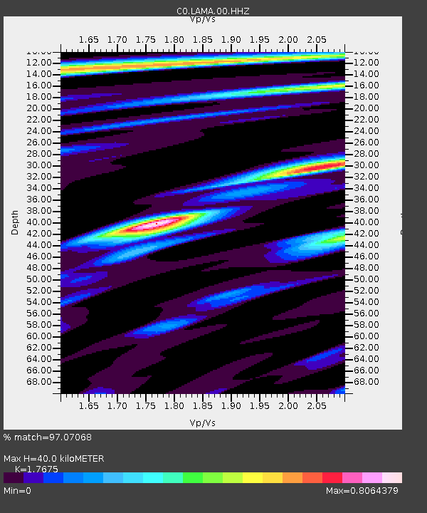
| Estimated Moho Depth: |
40.0 km |
| Estimated Crust Vp/Vs: |
1.77 |
| Assumed Crust Vp: |
6.242 km/s |
| Estimated Crust Vs: |
3.532 km/s |
| Estimated Crust Poisson's Ratio: |
0.26 |
|
| Radial Match: |
97.07068 % |
| Radial Bump: |
364 |
| Transverse Match: |
90.94685 % |
| Transverse Bump: |
400 |
| SOD ConfigId: |
27527651 |
| Insert Time: |
2022-03-30 15:24:09.745 +0000 |
| GWidth: |
2.5 |
| Max Bumps: |
400 |
| Tol: |
0.001 |
|

Signal To Noise
| Channel | StoN | STA | LTA |
| C0:LAMA:00:HHZ:20220316T14:48:25.724022Z | 22.867407 | 2.326059E-6 | 1.017194E-7 |
| C0:LAMA:00:HHN:20220316T14:48:25.724022Z | 4.8731008 | 4.9631655E-7 | 1.01848194E-7 |
| C0:LAMA:00:HHE:20220316T14:48:25.724022Z | 4.1278567 | 4.823311E-7 | 1.16847836E-7 |
| Arrivals |
| Ps | 5.0 SECOND |
| PpPs | 17 SECOND |
| PsPs/PpSs | 22 SECOND |


