You are here: Home > Network List > CC - Cascade Chain Volcano Monitoring Stations List
> Station PR04 Puyallup River 04 > Earthquake Result Viewer
PR04 Puyallup River 04 - Earthquake Result Viewer
| Earthquake location: |
Near East Coast Of Honshu, Japan |
| Earthquake latitude/longitude: |
37.7/141.6 |
| Earthquake time(UTC): |
2022/03/16 (075) 14:36:33 GMT |
| Earthquake Depth: |
63 km |
| Earthquake Magnitude: |
7.3 mww |
| Earthquake Catalog/Contributor: |
NEIC PDE/us |
|
| Network: |
CC Cascade Chain Volcano Monitoring |
| Station: |
PR04 Puyallup River 04 |
| Lat/Lon: |
46.93 N/121.99 W |
| Elevation: |
908 m |
|
| Distance: |
67.5 deg |
| Az: |
47.488 deg |
| Baz: |
301.446 deg |
| Ray Param: |
0.056783397 |
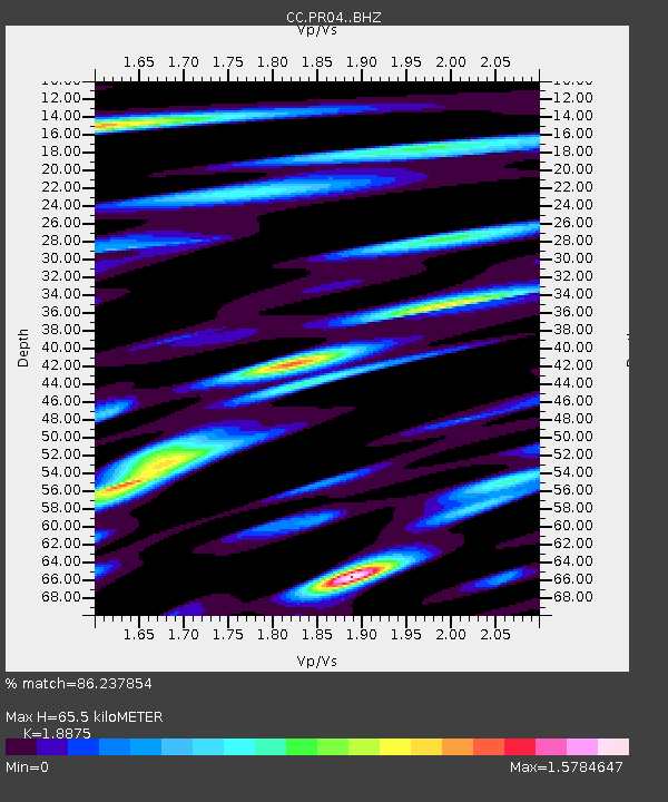
| Estimated Moho Depth: |
65.5 km |
| Estimated Crust Vp/Vs: |
1.89 |
| Assumed Crust Vp: |
6.597 km/s |
| Estimated Crust Vs: |
3.495 km/s |
| Estimated Crust Poisson's Ratio: |
0.30 |
|
| Radial Match: |
86.237854 % |
| Radial Bump: |
400 |
| Transverse Match: |
73.49377 % |
| Transverse Bump: |
400 |
| SOD ConfigId: |
27527651 |
| Insert Time: |
2022-03-30 15:25:36.230 +0000 |
| GWidth: |
2.5 |
| Max Bumps: |
400 |
| Tol: |
0.001 |
|

Signal To Noise
| Channel | StoN | STA | LTA |
| CC:PR04: :BHZ:20220316T14:46:51.860008Z | 5.504936 | 4.909003E-6 | 8.9174563E-7 |
| CC:PR04: :BHN:20220316T14:46:51.860008Z | 3.3486218 | 1.5649522E-6 | 4.6734218E-7 |
| CC:PR04: :BHE:20220316T14:46:51.860008Z | 4.127507 | 1.8504953E-6 | 4.4833243E-7 |
| Arrivals |
| Ps | 9.2 SECOND |
| PpPs | 28 SECOND |
| PsPs/PpSs | 37 SECOND |


