You are here: Home > Network List > CC - Cascade Chain Volcano Monitoring Stations List
> Station LOO Loowit > Earthquake Result Viewer
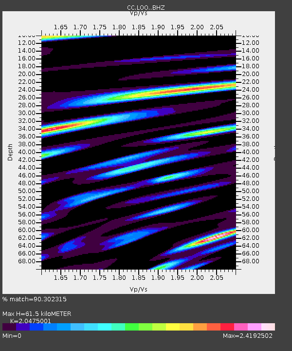
LOO Loowit - Earthquake Result Viewer
| Earthquake location: |
Near East Coast Of Honshu, Japan |
| Earthquake latitude/longitude: |
37.7/141.6 |
| Earthquake time(UTC): |
2022/03/16 (075) 14:36:33 GMT |
| Earthquake Depth: |
63 km |
| Earthquake Magnitude: |
7.3 mww |
| Earthquake Catalog/Contributor: |
NEIC PDE/us |
|
| Network: |
CC Cascade Chain Volcano Monitoring |
| Station: |
LOO Loowit |
| Lat/Lon: |
46.22 N/122.18 W |
| Elevation: |
1521 m |
|
| Distance: |
67.8 deg |
| Az: |
48.215 deg |
| Baz: |
301.581 deg |
| Ray Param: |
0.056612447 |
| Estimated Moho Depth: |
61.5 km |
| Estimated Crust Vp/Vs: |
2.05 |
| Assumed Crust Vp: |
6.566 km/s |
| Estimated Crust Vs: |
3.207 km/s |
| Estimated Crust Poisson's Ratio: |
0.34 |
|
| Radial Match: |
90.302315 % |
| Radial Bump: |
400 |
| Transverse Match: |
91.22582 % |
| Transverse Bump: |
400 |
| SOD ConfigId: |
27527651 |
| Insert Time: |
2022-03-30 15:26:12.750 +0000 |
| GWidth: |
2.5 |
| Max Bumps: |
400 |
| Tol: |
0.001 |
|

Signal To Noise
| Channel | StoN | STA | LTA |
| CC:LOO: :BHZ:20220316T14:46:53.440025Z | 16.048006 | 6.2077993E-6 | 3.8682685E-7 |
| CC:LOO: :BHN:20220316T14:46:53.440025Z | 0.88928473 | 9.148029E-7 | 1.0286951E-6 |
| CC:LOO: :BHE:20220316T14:46:53.440025Z | 3.6496968 | 3.574316E-6 | 9.79346E-7 |
| Arrivals |
| Ps | 10 SECOND |
| PpPs | 28 SECOND |
| PsPs/PpSs | 38 SECOND |


