You are here: Home > Network List > CI - Caltech Regional Seismic Network Stations List
> Station CIA CIA, Avalon Catalina Island, CA, USA > Earthquake Result Viewer
CIA CIA, Avalon Catalina Island, CA, USA - Earthquake Result Viewer
| Earthquake location: |
Near East Coast Of Honshu, Japan |
| Earthquake latitude/longitude: |
37.7/141.6 |
| Earthquake time(UTC): |
2022/03/16 (075) 14:36:33 GMT |
| Earthquake Depth: |
63 km |
| Earthquake Magnitude: |
7.3 mww |
| Earthquake Catalog/Contributor: |
NEIC PDE/us |
|
| Network: |
CI Caltech Regional Seismic Network |
| Station: |
CIA CIA, Avalon Catalina Island, CA, USA |
| Lat/Lon: |
33.40 N/118.41 W |
| Elevation: |
467 m |
|
| Distance: |
77.4 deg |
| Az: |
57.587 deg |
| Baz: |
306.824 deg |
| Ray Param: |
0.05024267 |
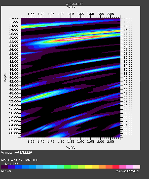
| Estimated Moho Depth: |
20.25 km |
| Estimated Crust Vp/Vs: |
1.87 |
| Assumed Crust Vp: |
6.048 km/s |
| Estimated Crust Vs: |
3.243 km/s |
| Estimated Crust Poisson's Ratio: |
0.30 |
|
| Radial Match: |
93.52229 % |
| Radial Bump: |
335 |
| Transverse Match: |
85.256714 % |
| Transverse Bump: |
400 |
| SOD ConfigId: |
27527651 |
| Insert Time: |
2022-03-30 15:26:46.335 +0000 |
| GWidth: |
2.5 |
| Max Bumps: |
400 |
| Tol: |
0.001 |
|
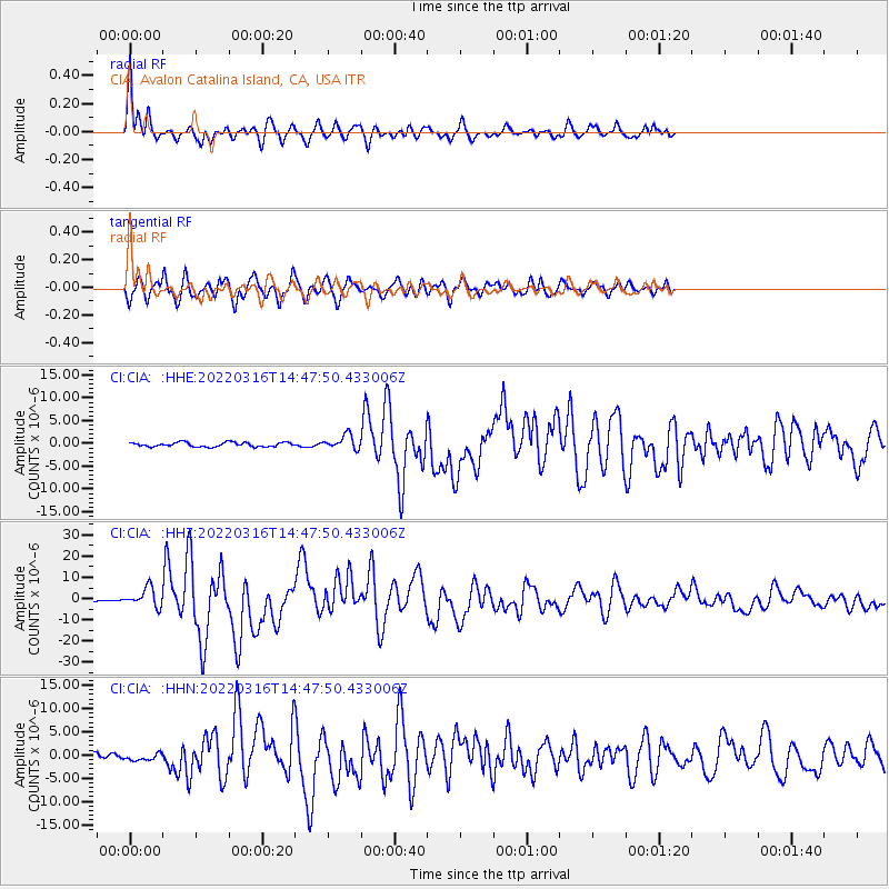
Signal To Noise
| Channel | StoN | STA | LTA |
| CI:CIA: :HHZ:20220316T14:47:50.433006Z | 9.719146 | 4.4245166E-6 | 4.552372E-7 |
| CI:CIA: :HHN:20220316T14:47:50.433006Z | 1.6091717 | 7.7710223E-7 | 4.829206E-7 |
| CI:CIA: :HHE:20220316T14:47:50.433006Z | 3.3102927 | 1.5579792E-6 | 4.7064697E-7 |
| Arrivals |
| Ps | 3.0 SECOND |
| PpPs | 9.4 SECOND |
| PsPs/PpSs | 12 SECOND |


