You are here: Home > Network List > CI - Caltech Regional Seismic Network Stations List
> Station FMP Fort MacArthur Park, Pt. Fermin San Pedro, CA, USA > Earthquake Result Viewer
FMP Fort MacArthur Park, Pt. Fermin San Pedro, CA, USA - Earthquake Result Viewer
| Earthquake location: |
Near East Coast Of Honshu, Japan |
| Earthquake latitude/longitude: |
37.7/141.6 |
| Earthquake time(UTC): |
2022/03/16 (075) 14:36:33 GMT |
| Earthquake Depth: |
63 km |
| Earthquake Magnitude: |
7.3 mww |
| Earthquake Catalog/Contributor: |
NEIC PDE/us |
|
| Network: |
CI Caltech Regional Seismic Network |
| Station: |
FMP Fort MacArthur Park, Pt. Fermin San Pedro, CA, USA |
| Lat/Lon: |
33.71 N/118.29 W |
| Elevation: |
89 m |
|
| Distance: |
77.3 deg |
| Az: |
57.271 deg |
| Baz: |
306.821 deg |
| Ray Param: |
0.050310723 |
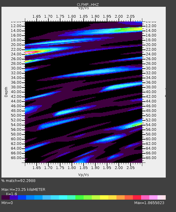
| Estimated Moho Depth: |
23.25 km |
| Estimated Crust Vp/Vs: |
1.60 |
| Assumed Crust Vp: |
6.048 km/s |
| Estimated Crust Vs: |
3.78 km/s |
| Estimated Crust Poisson's Ratio: |
0.18 |
|
| Radial Match: |
92.2988 % |
| Radial Bump: |
400 |
| Transverse Match: |
89.4823 % |
| Transverse Bump: |
400 |
| SOD ConfigId: |
27527651 |
| Insert Time: |
2022-03-30 15:27:05.555 +0000 |
| GWidth: |
2.5 |
| Max Bumps: |
400 |
| Tol: |
0.001 |
|

Signal To Noise
| Channel | StoN | STA | LTA |
| CI:FMP: :HHZ:20220316T14:47:49.847984Z | 8.941106 | 4.491009E-6 | 5.022879E-7 |
| CI:FMP: :HHN:20220316T14:47:49.847984Z | 1.8247083 | 1.3322499E-6 | 7.3011665E-7 |
| CI:FMP: :HHE:20220316T14:47:49.847984Z | 2.3320966 | 2.1786855E-6 | 9.3421755E-7 |
| Arrivals |
| Ps | 2.4 SECOND |
| PpPs | 9.7 SECOND |
| PsPs/PpSs | 12 SECOND |


