You are here: Home > Network List > CI - Caltech Regional Seismic Network Stations List
> Station SMM Simmler, CA, USA > Earthquake Result Viewer
SMM Simmler, CA, USA - Earthquake Result Viewer
| Earthquake location: |
Near East Coast Of Honshu, Japan |
| Earthquake latitude/longitude: |
37.7/141.6 |
| Earthquake time(UTC): |
2022/03/16 (075) 14:36:33 GMT |
| Earthquake Depth: |
63 km |
| Earthquake Magnitude: |
7.3 mww |
| Earthquake Catalog/Contributor: |
NEIC PDE/us |
|
| Network: |
CI Caltech Regional Seismic Network |
| Station: |
SMM Simmler, CA, USA |
| Lat/Lon: |
35.31 N/120.00 W |
| Elevation: |
599 m |
|
| Distance: |
75.2 deg |
| Az: |
56.802 deg |
| Baz: |
305.749 deg |
| Ray Param: |
0.051706392 |
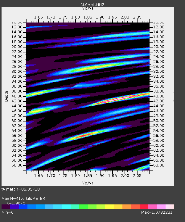
| Estimated Moho Depth: |
41.0 km |
| Estimated Crust Vp/Vs: |
1.97 |
| Assumed Crust Vp: |
6.1 km/s |
| Estimated Crust Vs: |
3.1 km/s |
| Estimated Crust Poisson's Ratio: |
0.33 |
|
| Radial Match: |
86.05718 % |
| Radial Bump: |
400 |
| Transverse Match: |
80.41774 % |
| Transverse Bump: |
400 |
| SOD ConfigId: |
27527651 |
| Insert Time: |
2022-03-30 15:28:10.879 +0000 |
| GWidth: |
2.5 |
| Max Bumps: |
400 |
| Tol: |
0.001 |
|
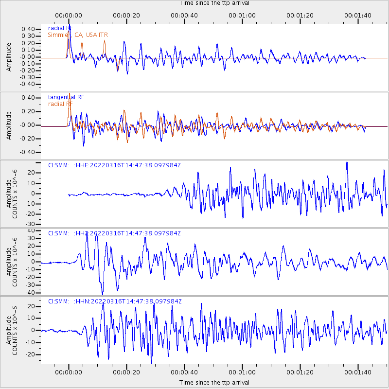
Signal To Noise
| Channel | StoN | STA | LTA |
| CI:SMM: :HHZ:20220316T14:47:38.097984Z | 10.796877 | 5.137536E-6 | 4.7583538E-7 |
| CI:SMM: :HHN:20220316T14:47:38.097984Z | 1.5954225 | 1.372188E-6 | 8.600781E-7 |
| CI:SMM: :HHE:20220316T14:47:38.097984Z | 2.4654126 | 1.6050516E-6 | 6.5102756E-7 |
| Arrivals |
| Ps | 6.7 SECOND |
| PpPs | 19 SECOND |
| PsPs/PpSs | 26 SECOND |


