You are here: Home > Network List > CN - Canadian National Seismograph Network Stations List
> Station KUKN Kugluktuk, NT, CA > Earthquake Result Viewer
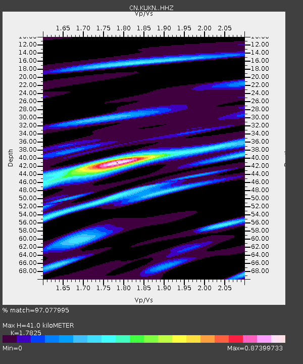
KUKN Kugluktuk, NT, CA - Earthquake Result Viewer
| Earthquake location: |
Near East Coast Of Honshu, Japan |
| Earthquake latitude/longitude: |
37.7/141.6 |
| Earthquake time(UTC): |
2022/03/16 (075) 14:36:33 GMT |
| Earthquake Depth: |
63 km |
| Earthquake Magnitude: |
7.3 mww |
| Earthquake Catalog/Contributor: |
NEIC PDE/us |
|
| Network: |
CN Canadian National Seismograph Network |
| Station: |
KUKN Kugluktuk, NT, CA |
| Lat/Lon: |
67.82 N/115.09 W |
| Elevation: |
51 m |
|
| Distance: |
60.4 deg |
| Az: |
25.144 deg |
| Baz: |
297.413 deg |
| Ray Param: |
0.061414704 |
| Estimated Moho Depth: |
41.0 km |
| Estimated Crust Vp/Vs: |
1.78 |
| Assumed Crust Vp: |
6.459 km/s |
| Estimated Crust Vs: |
3.624 km/s |
| Estimated Crust Poisson's Ratio: |
0.27 |
|
| Radial Match: |
97.077995 % |
| Radial Bump: |
303 |
| Transverse Match: |
91.216255 % |
| Transverse Bump: |
400 |
| SOD ConfigId: |
27527651 |
| Insert Time: |
2022-03-30 15:30:09.335 +0000 |
| GWidth: |
2.5 |
| Max Bumps: |
400 |
| Tol: |
0.001 |
|

Signal To Noise
| Channel | StoN | STA | LTA |
| CN:KUKN: :HHZ:20220316T14:46:05.329979Z | 41.548725 | 9.300432E-6 | 2.2384398E-7 |
| CN:KUKN: :HHN:20220316T14:46:05.329979Z | 7.052499 | 1.2085117E-6 | 1.7135936E-7 |
| CN:KUKN: :HHE:20220316T14:46:05.329979Z | 26.361353 | 4.448837E-6 | 1.687636E-7 |
| Arrivals |
| Ps | 5.2 SECOND |
| PpPs | 17 SECOND |
| PsPs/PpSs | 22 SECOND |


