You are here: Home > Network List > GM - US Geological Survey Networks Stations List
> Station NMP44 New Mexico Permian - Site# W4S4 > Earthquake Result Viewer
NMP44 New Mexico Permian - Site# W4S4 - Earthquake Result Viewer
| Earthquake location: |
Near East Coast Of Honshu, Japan |
| Earthquake latitude/longitude: |
37.7/141.6 |
| Earthquake time(UTC): |
2022/03/16 (075) 14:36:33 GMT |
| Earthquake Depth: |
63 km |
| Earthquake Magnitude: |
7.3 mww |
| Earthquake Catalog/Contributor: |
NEIC PDE/us |
|
| Network: |
GM US Geological Survey Networks |
| Station: |
NMP44 New Mexico Permian - Site# W4S4 |
| Lat/Lon: |
32.20 N/103.62 W |
| Elevation: |
1086 m |
|
| Distance: |
87.7 deg |
| Az: |
50.377 deg |
| Baz: |
313.889 deg |
| Ray Param: |
0.043057133 |
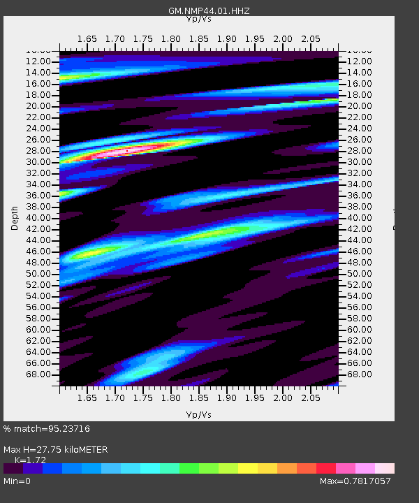
| Estimated Moho Depth: |
27.75 km |
| Estimated Crust Vp/Vs: |
1.72 |
| Assumed Crust Vp: |
6.129 km/s |
| Estimated Crust Vs: |
3.563 km/s |
| Estimated Crust Poisson's Ratio: |
0.24 |
|
| Radial Match: |
95.23716 % |
| Radial Bump: |
391 |
| Transverse Match: |
88.180916 % |
| Transverse Bump: |
400 |
| SOD ConfigId: |
27527651 |
| Insert Time: |
2022-03-30 15:33:57.362 +0000 |
| GWidth: |
2.5 |
| Max Bumps: |
400 |
| Tol: |
0.001 |
|

Signal To Noise
| Channel | StoN | STA | LTA |
| GM:NMP44:01:HHZ:20220316T14:48:43.610008Z | 8.359634 | 3.0631754E-6 | 3.6642456E-7 |
| GM:NMP44:01:HHN:20220316T14:48:43.610008Z | 2.5225592 | 6.5140387E-7 | 2.5823135E-7 |
| GM:NMP44:01:HHE:20220316T14:48:43.610008Z | 2.0203414 | 5.310427E-7 | 2.62848E-7 |
| Arrivals |
| Ps | 3.3 SECOND |
| PpPs | 12 SECOND |
| PsPs/PpSs | 15 SECOND |


