You are here: Home > Network List > GM - US Geological Survey Networks Stations List
> Station NMP51 New Mexico Permian - Site# W5S1 > Earthquake Result Viewer
NMP51 New Mexico Permian - Site# W5S1 - Earthquake Result Viewer
| Earthquake location: |
Near East Coast Of Honshu, Japan |
| Earthquake latitude/longitude: |
37.7/141.6 |
| Earthquake time(UTC): |
2022/03/16 (075) 14:36:33 GMT |
| Earthquake Depth: |
63 km |
| Earthquake Magnitude: |
7.3 mww |
| Earthquake Catalog/Contributor: |
NEIC PDE/us |
|
| Network: |
GM US Geological Survey Networks |
| Station: |
NMP51 New Mexico Permian - Site# W5S1 |
| Lat/Lon: |
32.00 N/103.42 W |
| Elevation: |
975 m |
|
| Distance: |
87.9 deg |
| Az: |
50.405 deg |
| Baz: |
313.995 deg |
| Ray Param: |
0.04286583 |
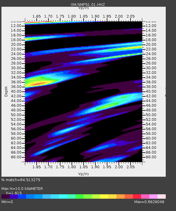
| Estimated Moho Depth: |
10.0 km |
| Estimated Crust Vp/Vs: |
1.62 |
| Assumed Crust Vp: |
6.129 km/s |
| Estimated Crust Vs: |
3.795 km/s |
| Estimated Crust Poisson's Ratio: |
0.19 |
|
| Radial Match: |
94.513275 % |
| Radial Bump: |
400 |
| Transverse Match: |
82.51499 % |
| Transverse Bump: |
400 |
| SOD ConfigId: |
27527651 |
| Insert Time: |
2022-03-30 15:34:00.419 +0000 |
| GWidth: |
2.5 |
| Max Bumps: |
400 |
| Tol: |
0.001 |
|

Signal To Noise
| Channel | StoN | STA | LTA |
| GM:NMP51:01:HHZ:20220316T14:48:44.844994Z | 10.187404 | 2.8029308E-6 | 2.751369E-7 |
| GM:NMP51:01:HHN:20220316T14:48:44.844994Z | 3.0255053 | 6.49222E-7 | 2.14583E-7 |
| GM:NMP51:01:HHE:20220316T14:48:44.844994Z | 4.6672196 | 6.4339014E-7 | 1.37853E-7 |
| Arrivals |
| Ps | 1.0 SECOND |
| PpPs | 4.2 SECOND |
| PsPs/PpSs | 5.2 SECOND |


